
塔尔沙漠
| 塔尔沙漠 印度大沙漠 | |
|---|---|
 在印度拉贾斯坦邦的塔尔沙漠 | |
 塔尔沙漠生态区域地图 | |
| 生态 | |
| 生态带 | 东洋界 |
| 生物群系 | 荒漠和干燥疏灌丛 |
| 相邻地区 | 西北荆棘灌丛林 and 卡奇盐沼 |
| 地理 | |
| 面积 | 238,254 km2(91,990 sq mi) |
| 国家 | 印度 and 印度 |
| 印度(邦),巴基斯坦(省) | India: 拉贾斯坦邦, 古吉拉特邦, 哈里亚纳邦, 旁遮普邦, 巴基斯坦: 旁遮普省 and 信德省 |
| 坐标 | 27°N 71°E / 27°N 71°E |
| 气候 | 炎热 |
| 保护 | |
| 生物保护状况 | 脆弱[1] |
| 已保护 | 41,833平方公里 (18%)[2]% |
塔尔沙漠(英语:Thar Desert),亦称印度大沙漠,位于印度次大陆的西北部,是一片广袤的干旱地带,横跨印度与巴基斯坦两国,总面积达20万平方公里(约7.7万平方英里)。论面积,它是全球第18大的沙漠,同时也是世界第9大的炎热亚热带沙漠。
塔尔沙漠有约85%的面积位于印度境内,其余约15%则在巴基斯坦境内。[3]这片沙漠约占印度国土面积的4.56%。在印度的部分,超过6成的面积位于拉贾斯坦邦,其余则延伸至古吉拉特邦、旁遮普邦和哈里亚纳邦。巴基斯坦境内的塔尔沙漠延伸至信德省[4]和旁遮普省(在旁遮普省境内的部分称为乔利斯坦沙漠)。塔尔沙漠的北部、西部和东北部与印度河-恒河平原相邻,南部是卡奇盐沼,东部则以阿拉瓦利山脉为界。
在印度部分的塔尔沙漠中于2023年有项最新的古生物学发现,揭示有种生活在1.67亿年前的草食性恐龙群 - 叉龙科。这不仅是印度首次发现叉龙科恐龙化石,同时也是目前全球此类化石记录中年代最为古老的标本。[5]
沙漠化历史
[编辑]冰河时期沙漠化
[编辑]青藏高原在大约两万年前的末次冰盛期曾被面积约240万平方公里(93万平方英里)的巨大冰盖所覆盖。[6][7][8]导致强烈的辐射强迫效应出现 - 表示当时青藏高原的冰层,其单位面积反射到太空的辐射能量至少是高纬度地区冰层的4倍以上,进一步冷却当时上层的大气,[9]而深刻影响到这个区域的气候。由于缺乏因地表受热而形成的热低压,印度次大陆失去季风带来的降水。此地季风缺失,让沙哈拉地区降雨增多,塔尔沙漠则持续扩张,更多的尘埃被风吹拂,而沉积到阿拉伯海中,导致印度次大陆的生物栖息地带海拔下降。面对这种剧烈的气候转变,动物也随之反应,例如爪哇水鹿便由东南亚迁徙到印度(推测为当时的海平面较现今低约120米,东南亚岛屿(如苏门答腊、爪哇、婆罗洲)与亚洲大陆之间可能形成"巽他陆棚"(Sunda Shelf),可让让动物往西北方向迁徙)。[10]
萨拉斯瓦蒂河干涸造成的影响
[编辑]
1 = 远古河流
2 = 今日河流
3 = 今日塔尔沙漠
4 = 远古海岸
5 = 今日海岸
6 = 今日的城镇
7 = 干涸的萨特莱杰河及前哈拉帕文化时期的萨特莱杰河古河道。 (Clift et al. (2012)).
在10,000-8,000年前,一条格加尔-哈克拉河的古河道(被认为是古老的萨拉斯瓦蒂河),在与萨特莱杰河汇流后,流入印度河的岔流(三角洲河道) - 纳拉河,之后因改变河道,使得格加尔-哈克拉河成为一个由季风供水、无法流入大海,且现今成为最终流入塔尔沙漠的河流系统。[11][12][13][14]
当滋养这些河流的季风大约在5,000年前进一步减弱时,印度河流域文明(IVC)在此区域蓬勃发展,[11][13][14][b]沿着印度河河道兴起众多城市,如今已只剩遗址,散布在如卡利班甘(拉贾斯坦邦)、巴纳瓦利和拉吉加希(哈里亚纳邦)、朵拉维拉和洛塔(古吉拉特邦)等地。[15][web 1]
随着季风在4,000年前更加衰退,干涸的格加尔-哈克拉河变成间歇性河流,而导致当时繁盛的哈拉帕文明(印度河流域文明中的一支)也随之衰落,转变为规模较小的农业社群。[11][c][13][12][14]
地理
[编辑]

塔尔沙漠的东北部坐落于阿拉瓦利山脉间。沙漠向北延伸至旁遮普邦和哈里亚纳邦,沿海岸向南抵达卡奇盐沼,西面和西北面则与印度河的冲积平原相接。沙漠的大部分区域由巨大的流动沙丘覆盖,这些沙丘的沉积物主要来自冲积平原和海岸地区。由于每年季风来临时有强风吹拂,沙子极易移动。卢尼河是沙漠中唯一的河流。[16]年降雨量为100至500毫米(4至20英寸),几乎所有的雨水都在6月至9月之间降下。[3]
在塔尔沙漠境内,存在数个咸水湖,包括在拉贾斯坦邦的桑珀尔盐湖、库查曼盐湖(Kuchaman)、迪德瓦纳盐湖(Didwana)、帕奇帕德拉盐湖和法洛迪盐湖(Phalodi),以及古吉拉特邦的卡拉戈达盐湖(Kharaghoda)。这些湖泊在季风季节接收并汇集雨水,而在旱季则蒸发殆尽。湖中的盐分主要来自该地区经风化的岩石所产生。[17]
此外,考古学家也在塔尔沙漠的中旧石器时代中期地层中发现属于马格里布史前阿特里文化的石制工具。[18]
气候
[编辑]该地区的气候干旱,属亚热带气候。平均气温随季节变化,冬季的极端气温可能接近冰点,而夏季则可能超过50°C。年平均降雨量介于100至500毫米之间,且集中在短暂的7月至9月西南季风期间。[1]
塔尔沙漠同时拥有非常干燥的区域(西部的马鲁斯塔里地区(Marusthali region))和半沙漠区域(东部),后者的沙丘较少,降水量也稍微多一些。[19]
沙漠化防治
[编辑]


由于塔尔沙漠的土壤常年干燥,极易发生风蚀。强劲的风力会将沙漠表土吹往他处,部分沉积在周边的沃土中,同时也让沙漠内部的沙丘不断迁移。为解决这个问题,稳定沙丘的首要措施是利用灌木等材料构筑微型防风林,接着再对这些有屏障的沙丘进行植树造林 - 栽种灌木(例如虎刺、耳叶决明和蓖麻)以及树木(例如阿拉伯胶树、银合欢和大叶合欢)。此外有全长649公里的英迪拉·甘地运河,也为塔尔沙漠带来淡水资源。[3]这项水利工程的主要目标是遏制沙漠向肥沃区域扩张。
沙漠中的保护区
[编辑]塔尔沙漠中设置有数个保护区:
- 印度部分:
- 沙漠国家公园,位于拉贾斯坦邦,占地3,162平方公里(1,221平方英里),用来展现塔尔沙漠的生态系统,[20]园内有44个村庄。[21]其多样的动物群包括如南亚鸨(Chirotis nigricaps)、印度黑羚、印度瞪羚、狐狸、孟加拉狐、狼和狞猫。阿卡尔木化石公园中具有的贝壳和巨大的石化树干,保留有沙漠的地质历史。
- 塔尔查帕尔保护区,占地7平方公里(2.7平方英里),是一个重要的鸟类保护区。[21]位于拉贾斯坦邦谢加瓦蒂地区(Shekhawati region)的久鲁县,距离斋浦尔210公里(130英里)。这个保护区是大量印度黑羚、狐狸、狞猫、鹧鸪和沙鸡科的栖息地。
- 松达玛塔保护区(Sundha Mata Conservation Reserve ),占地117.49平方公里(45.36平方英里),位于拉贾斯坦邦的贾洛尔县。[22]
- 巴基斯坦部分:
生物多样性
[编辑]动物群
[编辑]塔尔沙漠相较于印度其他地区,反成为某些迅速消逝野生动物的重要栖息地,例如印度黑羚(Antilope cervicapra)、印度瞪羚(Gazella bennettii),以及库奇湿地的印度野驴(Equus hemionus khur)等,其数量相当可观。这或许与牠们高度适应沙漠环境有关:相较于其他地区的同类,这些的体型较小且多为夜行性。此外,此地的草原转为农田的速度相对较慢,以及当地比什诺伊人社群对当地动物积极保护,也可能是促成牠们能繁衍的原因。
塔尔沙漠中还栖息有其他哺乳动物,包括赤狐的一个亚种(Vulpes vulpes pusilla)和狞猫,以及种类繁多的爬行动物。 塔尔沙漠是141种迁徙性和本地沙漠鸟类的重要栖息地,其中包括各种猛禽,如鹞、隼、𫛭(buzzard)、红隼和秃鹫,以及短趾雕(Circaetus gallicus)、草原雕(Aquila rapax)、花雕(Aquila clanga)和印度猎隼(Falco jugger)等鸟种。
蓝孔雀则是塔尔地区常见的留鸟。这种鸟类是印度的国鸟和巴基斯坦旁遮普省的省鸟,人们经常可以在村落中的印度国树(菩提树)上看到牠们优雅的身影。
此外,被列为极度濒危的南亚鸨(Ardeotis nigriceps),是世界上体型最庞大的飞行鸟类之一,也以拉贾斯坦邦的塔尔沙漠中为家,牠们偏好开阔的草原和半干旱地带。
-
 一只在菩提树上的孔雀
 -
 正在吃 洽帕提(印度薄饼) 碎片的孔雀(信德省塔帕卡县)。
 -
 印度黑羚(雄性与雌性)
 -
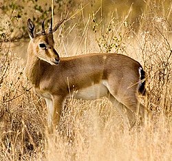 分布于塔尔沙漠各处的印度瞪羚。


植物群
[编辑].jpg)

这个干燥地区的天然植被被归类为西北部荆棘灌丛林(即稀疏散落的小片绿地)。[28][29]这些绿地的密度和大小从西向东,随着降雨量的增加而增加。塔尔沙漠的主要植被由乔木、灌木和多年生植物组成,包括:[30]
当地特有的植物物种有沙拐枣、印度圣树、阿拉伯金合欢 、无叶柽柳和双花蒺藜草。[31]
居民
[编辑]塔尔人是此地区的原住民。塔尔沙漠是世界上人口最稠密的沙漠,人口密度为每平方公里83人。[21]在印度部分,居民中有印度教徒、耆那教徒、锡克教徒和穆斯林。在巴基斯坦部分,居民有穆斯林和印度教徒。[32]
拉贾斯坦邦的人口中约有40%居住在塔尔沙漠。[33]住这里的居民主要从事农业和畜牧业。
久德浦是该地区的最大城市,位于沙漠边缘的灌丛林地带。比卡内尔和杰伊瑟尔梅尔是完全位于沙漠中的两个最大城市。


沙漠中的水资源与住房
[编辑]动植物和人类在真正的沙漠地带仰赖小型且分散的水塘维生,这些水塘有些是天然的(称为 "tobas"),有些则是人工挖掘的(称为"johad")。 塔尔沙漠普遍存在水源不足的问题,居民的生活深受其影响,并迫使许多人转向游居的生活方式。 多数永久性的人类聚落则集中在卡龙贾尔山一带的两条季节性河流附近。 此外,塔尔沙漠的地下水资源也相当匮乏,而且由于其中溶解有矿物质,多半带有咸味,难以饮用。 可供饮用的淡水,主要仅存在于地底深处。 因此,一旦有人成功挖出水质甘甜的井,往往会吸引人们前往定居。然而,凿井工程既艰巨又危险,时常造成人员伤亡。
部分区域会有较高的人口密度,居住空间拥挤是常见的现象。
-
 塔尔沙漠中的茅草小屋
 -
 人工挖掘,称为Johad的水塘是沙漠中常见的水源
 -
 当地用于储存饮用水的水槽


经济
[编辑]农业
[编辑]塔尔沙漠是世界上人口密度最高的沙漠地区之一,农业和畜牧业是当地居民的主要生计来源。[34]
该地区的农业生产以夏季种植的卡里夫作物(又称雨季作物或秋季作物)为主,这些作物于6月和7月播种,9月和10月采收,包括有小米、豆类(如瓜尔豆)、高粱、玉米、芝麻和花生。
此外,拉贾斯坦邦的塔尔地区也是重要的鸦片产地和消费地。[35][36]


牲畜
[编辑]![源自巴基斯坦信德省塔帕卡县的塔帕卡牛(英语:Tharparkar cattle),自第一次世界大战开始后广受欢迎。[37]](/wiki/File:Tharparkar_02.JPG)

农林业
[编辑]
报告指出印度圣树 (P. cineraria) 的木材具有很高的热值,是优质的薪柴来源。修剪下来的树枝非常适合用作围篱材料。其根部还能促进固氮作用,而提高农作物的产量。[38]
_1.jpg)
生态旅游
[编辑]在杰伊瑟尔梅尔一带,骑乘骆驼进行沙漠探险的行程日益盛行。国内外游客纷纷来到这片沙漠,展开为期一至数天的骆驼探险之旅。[39]这种生态旅游产业发展蓬勃,服务范围广泛,从较经济实惠的背包客徒步行程,到提供盛宴和文化表演等活动的豪华阿拉伯之夜风格营地,应有尽有。游客透过这些旅程得以亲身体验塔尔沙漠独特而脆弱的生态系统之美。这类旅游活动不仅为杰伊瑟尔梅尔的业者和骆驼主人带来可观收入,也为邻近沙漠村庄的骆驼向导创造许多就业机会。此外,世界各地的游客也慕名前来,希望一睹每年一度的普什卡市集的盛况,以及沙漠绿洲的风采。[40][41]
-
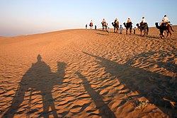 参与生态旅游活动者在近杰伊瑟尔梅尔沙漠中的骑骆驼活动。
 -
 塔尔沙漠的日出。


工业
[编辑]印度政府分别于1955年和1956年在杰伊瑟尔梅尔地区启动石油探勘计划,[42]而印度石油有限公司则在1988年于该地区的盆地发现有天然气的蕴藏。[43]
历史
[编辑]在杰伊瑟尔梅尔的沙漠国家公园,拥有丰富的收藏,包括近1.8亿年前的古老动植物化石。
杰伊瑟尔梅尔土邦的历史,与曾统治广大领域的巴蒂王朝密不可分。巴蒂王朝的势力范围,从现今的阿富汗加兹尼,[44]扩展到现今巴基斯坦的锡亚尔科特、拉合尔和拉瓦尔品第,[45]以及现今印度的巴廷达和赫努曼格尔等区域。[46]因为来自中亚的入侵持续不断,巴蒂王朝逐渐走向衰亡。根据著名的印度历史学家萨蒂什·钱德拉的说法,有个领土包括有阿富汗及印度土地的印度沙希王朝为终止加兹尼突厥统治者发动的掳人为奴袭击,曾与木尔坦的巴蒂王朝建立同盟,但这个联盟在公元977年被加兹尼王朝奠基人阿尔普特勤所破坏。在此之后,巴蒂王朝的领地不断向南迁移,他们先是统治木尔坦,最后被迫退守乔里斯坦沙漠和杰伊瑟尔梅尔。巴蒂王朝统治者拉瓦尔·德瓦拉贾(Rawal Devaraja)在此建设德拉瓦尔(Dera Rawal / Derawar) 这个地名后来演变成德拉瓦堡。杰伊瑟尔梅尔土邦的创始者拉瓦尔·斋沙尔于1156年将杰伊瑟尔梅尔设为新都,土邦名称也以这个新都为名。
杰伊瑟尔梅尔土邦于1818年12月11日经由英国设置的拉杰普塔纳代理机构管理而成为其保护国。[47][48]
由于土邦长久以来的收入主要仰赖向经过此地的商队征税,但自从孟买崛起成为主要港口,海上贸易大幅取代传统的陆路贸易路线后,土邦的经济便遭受严重冲击。两位统治者马哈拉瓦尔·兰吉特·辛格(Maharawals Ranjit Singh)和拜里·萨尔·辛格(Bairi Sal Singh)曾试图力挽狂澜,扭转颓势,但土邦的经济状况仍持续恶化。雪上加霜的是在马哈拉瓦尔·萨利瓦汉·辛格(Maharawal Salivahan Singh)统治期间 - 当地于1895年至1900年间发生过严重的旱灾,进而导致大规模饥荒,导致邦内赖以为生的牲畜大量死亡,对于本已衰弱的经济更是雪上加霜。
印度于1947年脱离英国统治,宣布独立。当时土邦的统治者马哈拉瓦尔·贾瓦希尔·辛格(Maharawal Jawahir Singh)是率先签署加入书,同意加入联邦的统治者之一。[49]印度联邦于1956年设立拉贾斯坦邦,在邦内的所有王室均失去主权,但享有王室年金。印度议会最终于1970-71年决议,停止支付此种王室年金。[49]
印巴冲突
[编辑]印巴两国间自印度于1947年独立以来,共发生过6次较具规模的武装冲突(包括2025年4月22日在印控克什米尔地区帕哈尔加姆附近在发生的袭击游客事件。印度和巴基斯坦在双方克什米尔边界的实质控制线上爆发小规模冲突和外交危机。)。
在1971年发生的第三次印巴战争中,有一场颇为激烈的隆格瓦拉战役,就发生于塔尔沙漠印度部分的边境城镇隆格瓦拉。印军以寡击众,成功抵挡巴军装甲兵部队的夜袭。尽管印军初期损失惨重,但在空军支援下,最终击退巴军,阻止其深入印度境内。印军凭借防守的优势,得以对巴基斯坦军队造成重大打击,导致200名士兵丧生,[50]36辆坦克被摧毁或遗弃,以及额外500辆车辆损失。[51]
印度与巴基斯坦于1965年和1971年在塔尔沙漠地区进行人口互换。约有3,500名穆斯林从印度控制的塔尔区域迁往巴基斯坦控制的区域,同时也有数千名印度教家庭自巴基斯坦控制的塔尔区域迁至印度控制的区域。[52][53][54]

参见
[编辑]
- 干旱森林研究所
- [1](旱地资讯网络,Arid Lands Information Network)
- 干旱化
- 乔里斯坦沙漠
- 纳拉沙漠
- 极强气旋风暴菲特
- 森林砍伐
- 印度地理
- 塔帕卡县#历史
- 世界沙漠面积列表
- 马尔瓦尔,印度西北部拉贾斯坦邦西部的一个地区。它部分位于塔尔沙漠。
- 波卡兰,印度拉贾斯坦邦吉撒摩县的一个城镇
- 塔尔人,是塔尔沙漠地区的原住民
注记
[编辑]- ^ See Clift et al. (2012) map and Honde te al. (2017) map.
- ^ In contrast to the mainstream view, Chatterjee et al. (2019) suggest that the river remained perennial till 4,500 years ago.
- ^ Giosan et al. (2012):
- "Contrary to earlier assumptions that a large glacier-fed Himalayan river, identified by some with the mythical Sarasvati, watered the Harappan heartland on the interfluve between the Indus and Ganges basins, we show that only monsoonal-fed rivers were active there during the Holocene."
- "Numerous speculations have advanced the idea that the Ghaggar-Hakra fluvial system, at times identified with the lost mythical river of Sarasvati (e.g., 4, 5, 7, 19), was a large glacier fed Himalayan river. Potential sources for this river include the Yamuna River, the Sutlej River, or both rivers. However, the lack of large-scale incision on the interfluve demonstrates that large, glacier-fed rivers did not flow across the Ghaggar-Hakra region during the Holocene
- "The present Ghaggar-Hakra valley and its tributary rivers are currently dry or have seasonal flows. Yet rivers were undoubtedly active in this region during the Urban Harappan Phase. We recovered sandy fluvial deposits approximately 5;400 y old at Fort Abbas in Pakistan (SI Text), and recent work (33) on the upper Ghaggar-Hakra interfluve in India also documented Holocene channel sands that are approximately 4;300 y old. On the upper interfluve, fine-grained floodplain deposition continued until the end of the Late Harappan Phase, as recent as 2,900 y ago (33) (Fig. 2B). This widespread fluvial redistribution of sediment suggests that reliable monsoon rains were able to sustain perennial rivers earlier during the Holocene and explains why Harappan settlements flourished along the entire Ghaggar-Hakra system without access to a glacier-fed river."
参考文献
[编辑]- ^ 1.0 1.1 Thar Desert. 陆地生态区. 世界野生动物基金会.
- ^ Dinerstein, Eric; Olson, David; et al. An Ecoregion-Based Approach to Protecting Half the Terrestrial Realm. BioScience. 2017, 67 (6): 534–545 [Supplemental material 2 table S1b]. PMC 5451287
 . PMID 28608869. doi:10.1093/biosci/bix014.
- ^ 3.0 3.1 3.2 Sinha, R. K.; Bhatia, S. & Vishnoi, R. Desertification control and rangeland management in the Thar desert of India. RALA Report No. 200. 1996: 115–123.
- ^ Sharma, K. K.; Mehra, S. P. The Thar of Rajasthan (India): Ecology and Conservation of a Desert Ecosystem. Sivaperuman, C.; Baqri, Q. H.; Ramaswamy, G.; Naseema, M. (编). Faunal Ecology and Conservation of the Great Indian Desert. Berlin Heidelberg: Springer. 2009: 1–11. ISBN 978-3-540-87408-9. doi:10.1007/978-3-540-87409-6_1.
- ^ The Oldest Plant-Eating Dinosaur Has Been Found in India. The New York Times. 2023-08-19 [23 August 2023] (英语).
- ^ Kuhle, Matthias. Reconstruction of the 2.4 Million km2 Late Pleistocene Ice Sheet on the Tibetan Plateau and its Impact on the Global Climate. Quaternary International. 1998, 45/46: 71–108. Bibcode:1998QuInt..45...71K. doi:10.1016/S1040-6182(97)00008-6.
- ^ Kuhle, M. The High Glacial (Last Ice Age and LGM) ice cover in High and Central Asia. Ehlers, J.; Gibbard, P.L. (编). Development in Quaternary Science 2c (Quaternary Glaciation – Extent and Chronology, Part III: South America, Asia, Africa, Australia, Antarctica). 2004: 175–99.
- ^ Kuhle, M. Tibet and High Asia V. Results of Investigations into High Mountain Geomorphology, Paleo-Glaciology and Climatology of the Pleistocene. GeoJournal. 1999, 47 (1–2): 3–276. S2CID 128089823. doi:10.1023/A:1007039510460. See chapter entitled: "Reconstruction of an approximately complete Quaternary Tibetan Inland Glaciation between the Mt. Everest and Cho Oyu Massifs and the Aksai Chin. – A new glaciogeomorphological southeast-northwest diagonal profile through Tibet and its consequences for the glacial isostasy and Ice Age cycle".
- ^ Kuhle, M. The Pleistocene Glaciation of Tibet and the Onset of Ice Ages – An Autocycle Hypothesis. GeoJournal. 1988, 17 (4): 581–96. S2CID 129234912. doi:10.1007/BF00209444. Tibet and High-Asia I. Results of the Sino-German Joint Expeditions (I).
- ^ Kuhle, Matthias. The Tibetan Ice Sheet; its Impact on the Palaeomonsoon and Relation to the Earth's Orbital Variations. Polarforschung. 2001, 71 (1/2): 1–13.
- ^ 11.0 11.1 11.2 Giosan et al. 2012.
- ^ 12.0 12.1 Maemoku et al. 2013.
- ^ 13.0 13.1 13.2 Clift et al. 2012.
- ^ 14.0 14.1 14.2 Singh et al. 2017.
- ^ Sankaran 1999.
- ^ Laity, J. J. Deserts and Desert Environments. John Wiley & Sons. 2009. ISBN 9781444300741.
- ^ Ramesh, R.; Jani, R. A. & Bhushan, R. Stable isotopic evidence for the origin of salt lakes in the Thar desert. Journal of Arid Environments. 1993, 25 (1): 117–123. Bibcode:1993JArEn..25..117R. doi:10.1006/jare.1993.1047.
- ^ Gwen Robbins Schug, Subhash R. Walimbe. A Companion to South Asia in the Past. John Wiley & Sons. 2016: 64 [2016-05-06]. ISBN 978-1119055471.
- ^ Sharma, K. K., S. Kulshreshtha, A. R. Rahmani (2013). Faunal Heritage of Rajasthan, India: General Background and Ecology of Vertebrates. Springer Science & Business Media, New York.
- ^ Rahmani, A. R. The uncertain future of the Desert National Park in Rajasthan, India. Environmental Conservation. 1989, 16 (3): 237–244. S2CID 83995201. doi:10.1017/S0376892900009322.
- ^ 21.0 21.1 21.2 Singh, P. (ed.) (2007). "Report of the Task Force on Grasslands and Deserts" 互联网档案馆的存档,存档日期10 December 2011.. Government of India Planning Commission, New Delhi.
- ^ WII (2015). Conservation Reserves 互联网档案馆的存档,存档日期2015-04-10. Wildlife Institute of India, Dehradun.
- ^ Ghalib, S. A.; et al. Bioecology of Nara Desert Wildlife Sanctuary, Districts Ghotki, Sukkur and Khairpur, Sindh. Pakistan Journal of Zoology. 2008, 40 (1): 37–43. ISSN 0030-9923.
- ^ 24.0 24.1 Protected Areas. [21 April 2020]. (原始内容存档于3 February 2020).
- ^ Ghalib, S. A.; et al. Current distribution and status of the mammals, birds and reptiles in Rann of Kutch Wildlife Sanctuary, Sindh. International Journal of Biology and Biotechnology (Pakistan). 2014, 10 (4): 601–611 [21 August 2022]. ISSN 1810-2719. (原始内容存档于2023 -04-12).
- ^ Lal Suhanra. UNESCO. [28 December 2016].
- ^ UNESCO – MAB Biosphere Reserves Directory. unesco.org. [2020-04-21].
- ^ Champion, H. G.; Seth, S. K. A revised survey of the forest types of India. Government of India Press. 1968. OCLC 549213.
- ^ Negi, S. S. Biosphere Reserves in India: Landuse, Biodiversity and Conservation. Delhi: Indus Publishing Company. 1996. ISBN 9788173870439.
- ^ Kaul, R. N. Afforestation in arid zones. Monographiiae Biologicae 20. The Hague. 1970. OCLC 115047.
- ^ Khan, T. I. & Frost, S. Floral biodiversity: a question of survival in the Indian Thar Desert. Environmentalist. 2001, 21 (3): 231–236. S2CID 82472637. doi:10.1023/A:1017991606974.
- ^ Raza, Hassan. Mithi: Where a Hindu fasts and a Muslim does not slaughter cows. Dawn. 2012-03-05.
- ^ Gupta, M. L. (2008). Rajasthan Gyan Kosh. 3rd Edition. Jojo Granthagar, Jodhpur. ISBN 81-86103-05-8
- ^ Raza, Fawwad. Modern Agriculture Techniques in the Desert of THAR - Scientia Magazine. 2021-03-31 [2024-11-01].
- ^ ICMR Bulletin vol.38, No.1-3, Pattern and Process of Drug and Alcohol Use in India (PDF). [2022-05-10]. (原始内容 (PDF)存档于2022-03-28).
- ^ Will Rajasthan opium farmers vote for change?. [202205-10]. (原始内容存档于2022-05-10).
- ^ Breeds of Livestock - Tharparkar Cattle — Breeds of Livestock, Department of Animal Science. afs.okstate.edu. [2019-08-05].
- ^ González-Montemayor, Ángela-Mariela; Flores-Gallegos, Adriana C. Prosopis spp. functional activities and its applications in bakery products. Trends in Food Science & Technology. December 2019, 94: 12–19 [2025-05-13]. doi:10.1016/j.tifs.2019.09.023.
- ^ Gloria Apara. INDIA. Nomadic Chica. 2015-05-08 [2025-05-13]. 已忽略文本“ Jaisalmer and the Camel Safari ” (帮助)
- ^ David L. Gladstone. From Pilgrimage to Package Tour: Travel and Tourism in the Third World. Routledge. 2013: 179–186 [2017-10-24]. ISBN 978-1-136-07874-3. (原始内容存档于3 July 2023).
- ^ James G. Lochtefeld. The Illustrated Encyclopedia of Hinduism: N-Z
 . The Rosen Publishing Group. 2002: 539. ISBN 978-0-8239-3180-4.
- ^ PlanningCommission.NIC.in. [2009-11-16]. (原始内容存档于2006-04-14).
- ^ OilIndia.NIC.in 互联网档案馆的存档,存档日期2006-06-30.
- ^ Rajasthan or the Central and Western Rajpoot States, Volume 2, page 197-198. Higginbotham And Co. Madras. 2018-08-14.
- ^ Imperial Gazetter of India, Volume 21, page 272 - Imperial Gazetteer of India - Digital South Asia Library. Dsal.uchicago.edu. 2013-02-18 [2013-11-22].
- ^ Bhatinda Government: District at A glance- Origin. Bhatinda Government. 2018-08-14 [2018-08-14]. (原始内容存档于2011-01-10).
- ^ Princely States of India.
- ^ Provincial Gazetteers Of India: Rajputana. Government of India. 2018-08-14.
- ^ 49.0 49.1 Far East Kingdoms South Asia - Rajputana (Jaisalmer). The History Files. [2025-05-14].
- ^ Col J Francis (Retd). Short Stories from the History of the Indian Army Since August 1947. Vij Books India Pvt Ltd. 30 August 2013: 93–96. ISBN 978-93-82652-17-5.
- ^ Jaques, Tony. Dictionary of Battles and Sieges: A Guide to 8,500 Battles from Antiquity Through the Twenty-First Century. Greenwood. 2007: 597. ISBN 978-0313335389.
- ^ Hasan, Arif; Raza, Mansoor. Migration and Small Towns in Pakistan. IIED. 2009: 15–16. ISBN 9781843697343.
- ^ Maini, Tridivesh Singh. Not just another border. Himal South Asian. 15 August 2012.
- ^ Arisar, Allah Bux. Families separated by Pak-India border yearn to see their loved ones. News Lens Pakistan. 2015-10-06 [2016-12-25]. (原始内容存档于2016-12-25).
网页
[编辑]- ^ Mythical Saraswati River, Press Information Bureau, Government of India, 2013-03-20.互联网档案馆的存档,存档日期2016-10-09.
资讯来源
[编辑]- Chatterjee, Anirban; Ray, Jyotiranjan S.; Shukla, Anil D.; Pande, Kanchan. On the existence of a perennial river in the Harappan heartland. Scientific Reports. 20 November 2019, 9 (1): 17221. Bibcode:2019NatSR...917221C. ISSN 2045-2322. PMC 6868222 . PMID 31748611. doi:10.1038/s41598-019-53489-4 (英语).
- Clift, Peter D.; Carter, Andrew; Giosan, Liviu; Durcan, Julie; et al, U-Pb zircon dating evidence for a Pleistocene Sarasvati River and capture of the Yamuna River, Geology, 2012, 40 (3): 211–214, Bibcode:2012Geo....40..211C, S2CID 130765891, doi:10.1130/g32840.1
- Giosan; et al. Fluvial landscapes of the Harappan civilization. PNAS. 2012, 109 (26): E1688–E1694. Bibcode:2012PNAS..109E1688G. PMC 3387054 . PMID 22645375. doi:10.1073/pnas.1112743109 .
- Giosan, Liviu; Clift, Peter D.; Macklin, Mark G.; Fuller, Dorian Q. Sarasvati II. Current Science. 10 October 2013, 105 (7): 888–890. JSTOR 24098502.
- Khonde, Nitesh; Kumar Singh, Sunil; Maur, D. M.; Rai, Vinai K.; Chamyal, L. S.; Giosan, Liviu, Tracing the Vedic Saraswati River in the Great Rann of Kachchh, Scientific Reports, 2017, 7 (1): 5476, Bibcode:2017NatSR...7.5476K, PMC 5511136 , PMID 28710495, doi:10.1038/s41598-017-05745-8
- Maemoku, Hideaki; Shitaoka, Yorinao; Nagatomo, Tsuneto; Yagi, Hiroshi. Geomorphological Constraints on the Ghaggar River Regime During the Mature Harappan Period. Giosan, Liviu; Fuller, Dorian Q.; Nicoll, Kathleen; Flad, Rowan K.; Clift, Peter D. (编). Climates, Landscapes, and Civilizations. American Geophysical Union Monograph Series 198. John Wiley & Sons. 2013. ISBN 978-1-118-70443-1.
- Sankaran, A. V. Saraswati – The ancient river lost in the desert. Current Science. 25 October 1999, 77 (8): 1054–1060. JSTOR 24103577. (原始内容存档于19 September 2004).
- Singh, Ajit; et al. Counter-intuitive influence of Himalayan river morphodynamics on Indus Civilisation urban settlements. Nature Communications. 2017, 8 (1): 1617. Bibcode:2017NatCo...8.1617S. PMC 5705636 . PMID 29184098. doi:10.1038/s41467-017-01643-9.
- Valdiya, K.S. The River Saraswati was a Himalayan-born river (PDF). Current Science. 2013, 104 (1): 42.
延伸阅读
[编辑]- Bhandari M. M. Flora of The Indian Desert, MPS Repros, 39, BGKT Extension, New Pali Road, Jodhpur, India.
- Zaigham, N. A. (2003). "Strategic sustainable development of groundwater in Thar Desert of Pakistan". Water Resources in the South: Present Scenario and Future Prospects, Commission on Science and Technology for Sustainable Development in the South, Islamabad.
- Govt. of India. Ministry of Food & Agriculture booklet (1965)—"Soil conservation in the Rajasthan Desert"—Work of the Desert Afforestation Research station, Jodhpur.
- Gupta, R. K. & Prakash Ishwar (1975). Environmental analysis of the Thar Desert. English Book Depot., Dehra Dun.
- Kaul, R. N. (1967). "Trees or grass lands in the Rajasthan: Old problems and New approaches". Indian Forester, 93: 434–435.
- Burdak, L. R. (1982). "Recent Advances in Desert Afforestation". Dissertation submitted to Shri R. N. Kaul, Director, Forestry Research, F.R.I., Dehra Dun.
- Yashpal, Sahai Baldev, Sood, R.K., and Agarwal, D.P. (1980). "Remote sensing of the 'lost' Saraswati river". Proceedings of the Indian Academy of Sciences (Earth and Planet Science), V. 89, No. 3, pp. 317–331.
- Bakliwal, P. C. and Sharma, S. B. (1980). "On the migration of the river Yamuna". Journal of the Geological Society of India, Vol. 21, Sept. 1980, pp. 461–463.
- Bakliwal, P. C. and Grover, A. K. (1988). "Signature and migration of Sarasvati river in Thar desert, Western India". Record of the Geological Survey of India V 116, Pts. 3–8, pp. 77–86.
- Rajawat, A. S., Sastry, C. V. S. and Narain, A. (1999-a). "Application of pyramidal processing on high resolution IRS-1C data for tracing the migration of the Saraswati river in parts of the Thar desert". in "Vedic Sarasvati, Evolutionary History of a Lost River of Northwestern India", Memoir Geological Society of India, Bangalore, No. 42, pp. 259–272.
- Ramasamy, S. M. (1999). "Neotectonic controls on the migration of Sarasvati river of the Great Indian desert". in "Vedic Sarasvati, Evolutionary History of a Lost River of Northwestern India", Memoir Geological Society of India, Bangalore, No. 42, pp. 153–162.
- Rajesh Kumar, M., Rajawat, A. S. and Singh, T. N. (2005). "Applications of remote sensing for educidate the Palaeochannels in an extended Thar desert, Western Rajasthan", 8th annual International conference, Map India 2005, New Delhi.
外部链接
[编辑]- Template:Wikivoyage inline
- Thar Desert. 陆地生态区. 世界野生动物基金会.
- Dharssi.org.uk, Photos of the Thar Desert
- Avgustin.net, Photos of the Thar Desert in Pakistan side

Template:Geography of India Template:Geography of Pakistan Template:Sindh topics