聖安德魯區 (聖文森及格瑞那丁)
外观
| 聖安德魯區 Saint Andrew Parish | |
|---|---|
| 教区 | |
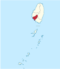
 Map of the Parish of Saint Andrew | |
| 坐标:13°12′00″N 061°15′58″W / 13.20000°N 61.26611°W | |
| 國家 | |
| 首府 | 拉尤 |
| 面积 | |
| • 总计 | 11 平方英里(29 平方公里) |
| 人口 | |
| • 總計 | 6,700人 |
聖安德魯區(英語:Saint Andrew Parish)是聖文森及格瑞那丁的一個行政教區,首府在拉尤。聖安德魯區面積29 km²,人口在2000年有6,700人。
聚居地
[编辑]以下是位於聖安德魯區的聚居地:[1]
- Camden Park(13°10′21″N 61°14′29″W / 13.17250°N 61.24139°W)[2]
- Chauncey(13°10′N 61°14′W / 13.167°N 61.233°W)
- Clare Valley(13°10′N 61°15′W / 13.167°N 61.250°W)
- Dubois(13°11′N 61°14′W / 13.183°N 61.233°W)
- Edinboro(13°09′35″N 61°14′11″W / 13.15972°N 61.23639°W)[3]
- Francois(13°12′N 61°13′W / 13.200°N 61.217°W)
- Liberty Lodge(13°09′57″N 61°13′54″W / 13.16583°N 61.23167°W)
- Montrose(13°10′N 61°14′W / 13.167°N 61.233°W)
- Pembroke(13°11′N 61°15′W / 13.183°N 61.250°W)
- 奎斯特尔斯(13°10′N 061°14′W / 13.167°N 61.233°W)
- Redemption(13°09′52″N 61°13′46″W / 13.16444°N 61.22944°W)
- 佛蒙特(13°12′N 61°13′W / 13.200°N 61.217°W)
| 这是一篇與聖文森及格瑞那丁相關的小作品。您可以通过编辑或修订扩充其内容。 |
- ^ GeoNames Search. National Geospatial-Intelligence Agency. [2 March 2013]. (原始内容存档于2017-03-18).
- ^ Camden Park. Wikimapia. [3 March 2013]. (原始内容存档于2020-01-03).
- ^ Edinboro. Wikimapia. [3 March 2013]. (原始内容存档于2019-12-26).
