
File:South China Sea vector.svg

此 SVG 檔案的 PNG 預覽的大小:637 × 600 像素。 其他解析度:255 × 240 像素 | 510 × 480 像素 | 816 × 768 像素 | 1,088 × 1,024 像素 | 2,176 × 2,048 像素 | 1,004 × 945 像素。
原始檔案 (SVG 檔案,表面大小:1,004 × 945 像素,檔案大小:657 KB)
摘要
| 描述 |
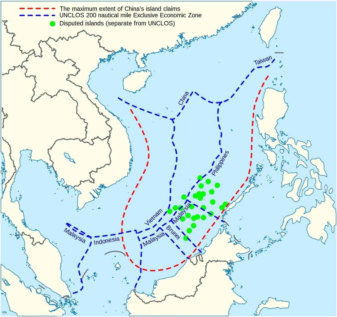
English: China's maritime claim (red) and UNCLOS exclusive economic zones (blue) in the South China Sea |
| 日期 | |
| 來源 |
自己的作品 |
| 作者 | Goran tek-en |
| SVG開發 | 本vector image使用Inkscape創作。 |


授權條款
此檔案採用創用CC 姓名標示-相同方式分享 4.0 國際授權條款。
姓名標示: Goran tek-en
- 您可以自由:
- 分享 – 複製、發佈和傳播本作品
- 重新修改 – 創作演繹作品
- 惟需遵照下列條件:
- 姓名標示 – 您必須指名出正確的製作者,和提供授權條款的連結,以及表示是否有對內容上做出變更。您可以用任何合理的方式來行動,但不得以任何方式表明授權條款是對您許可或是由您所使用。
- 相同方式分享 – 若要根據本素材進行再混合、轉換或創作,則必須以與原作相同或相容的授權來發布您的作品。
檔案歷史
點選日期/時間以檢視該時間的檔案版本。
| 日期/時間 | 縮圖 | 尺寸 | 使用者 | 備註 | |
|---|---|---|---|---|---|
| 目前 | 2022年2月15日 (二) 14:31 | | 1,004 × 945(657 KB) | ماني | File uploaded using svgtranslate tool (https://svgtranslate.toolforge.org/). Added translation for fa. |
| 2021年11月16日 (二) 15:44 |  | 1,004 × 945(651 KB) | Goran tek-en | ppi to 96, optimized, cleaned up | |
| 2014年11月9日 (日) 19:40 |  | 1,004 × 945(729 KB) | Cmglee | Label UNCLOS regions. | |
| 2014年5月19日 (一) 23:15 |  | 1,004 × 945(723 KB) | Benlisquare | Fix misinformation, see en:Talk:Nine-dotted line. The red line represents the extent of China's island claims, and not sea territory claims. China's maritime territorial claims are based on distance from claimed islands, and are not demarcated by... | |
| 2014年1月23日 (四) 14:40 |  | 1,004 × 945(722 KB) | Goran tek-en | User created page with UploadWizard |
檔案用途
沒有使用此檔案的頁面。
全域檔案使用狀況
以下其他 wiki 使用了這個檔案:
- af.wikipedia.org 的使用狀況
- cs.wikinews.org 的使用狀況
- en.wikipedia.org 的使用狀況
- fa.wikipedia.org 的使用狀況
- fi.wikipedia.org 的使用狀況
- fr.wikinews.org 的使用狀況
- fr.wiktionary.org 的使用狀況
- ja.wikipedia.org 的使用狀況
- kk.wikipedia.org 的使用狀況
- ko.wikipedia.org 的使用狀況
- pl.wikipedia.org 的使用狀況
- ru.wikipedia.org 的使用狀況
- simple.wikipedia.org 的使用狀況
- sq.wikipedia.org 的使用狀況
- th.wikipedia.org 的使用狀況
- vi.wikipedia.org 的使用狀況