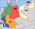
File:Map-Germany-1945.svg
外觀

此 SVG 檔案的 PNG 預覽的大小:706 × 600 像素。 其他解析度:283 × 240 像素 | 565 × 480 像素 | 904 × 768 像素 | 1,206 × 1,024 像素 | 2,411 × 2,048 像素 | 3,492 × 2,966 像素。
原始檔案 (SVG 檔案,表面大小:3,492 × 2,966 像素,檔案大小:726 KB)
檔案歷史
點選日期/時間以檢視該時間的檔案版本。
| 日期/時間 | 縮圖 | 尺寸 | 使用者 | 備註 | |
|---|---|---|---|---|---|
| 目前 | 2017年12月1日 (五) 04:37 |  | 3,492 × 2,966(726 KB) | Sammimack | Updated flags and colours |
| 2015年7月3日 (五) 14:13 |  | 3,492 × 2,966(728 KB) | Lichaosheng | New 48-Star US Flag from File:US flag 48 stars.svg | |
| 2015年7月3日 (五) 14:00 |  | 3,492 × 2,966(742 KB) | Lichaosheng | Reverted to version as of 18:46, 8 October 2008 | |
| 2012年2月4日 (六) 15:19 |  | 3,492 × 2,966(742 KB) | AnonMoos | Reverted to version as of 18:46, 8 October 2008 -- Kaliningrad had quite different status and fate from that of East Germany proper... | |
| 2012年1月20日 (五) 19:44 |  | 3,492 × 2,966(742 KB) | Sammy pompon | Kaliningrado is occuped by USSR. | |
| 2008年10月8日 (三) 18:46 |  | 3,492 × 2,966(742 KB) | File Upload Bot (Magnus Manske) | {{BotMoveToCommons|en.wikipedia}} {{Information |Description={{en|Occupation zone borders in Germany, 1947. The territories east of the en:Oder-Neisse line, under Polish and Soviet administration/annexation, are shown as white as is the likewise det |
檔案用途
下列9個頁面有用到此檔案:
全域檔案使用狀況
以下其他 wiki 使用了這個檔案:
- af.wikipedia.org 的使用狀況
- ar.wikipedia.org 的使用狀況
- arz.wikipedia.org 的使用狀況
- ast.wikipedia.org 的使用狀況
- azb.wikipedia.org 的使用狀況
- az.wikipedia.org 的使用狀況
- be.wikipedia.org 的使用狀況
- bs.wikipedia.org 的使用狀況
- ca.wikipedia.org 的使用狀況
- ckb.wikipedia.org 的使用狀況
- cs.wikipedia.org 的使用狀況
- cy.wikipedia.org 的使用狀況
- da.wikipedia.org 的使用狀況
- de.wikipedia.org 的使用狀況
- de.wikibooks.org 的使用狀況
- el.wikipedia.org 的使用狀況
- en.wikipedia.org 的使用狀況
檢視此檔案的更多全域使用狀況。


