
File:Kingdoms of Israel and Judah map 830.svg

此 SVG 檔案的 PNG 預覽的大小:502 × 599 像素。 其他解析度:201 × 240 像素 | 402 × 480 像素 | 644 × 768 像素 | 858 × 1,024 像素 | 1,717 × 2,048 像素 | 720 × 859 像素。
原始檔案 (SVG 檔案,表面大小:720 × 859 像素,檔案大小:96 KB)
| 描述 |
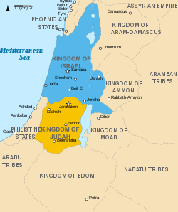
English: Approximate map showing (blue) and (orange), ancient Southern Levant borders and ancient cities such as Urmomium and Jerash. The map shows the region in the 9th century BCE. Italiano: Il regno di Giuda e quello di Israele nell'età del ferro (VIII secolo a.C.).
日本語: 紀元前830年代のユダ王国(黄色).
Русский: Царство Иудея 927 по 526 гг. до н. э. Отсюда иудеи были сосланы завоевателями в Вавилонский регион.
Bahasa Indonesia: Peta kerajaan-kerajaan di daerah tersebut pada abad 9 SM.
Simple English: The northern Kingdom of Israel and the Kingdom of Judah to the south.
Srpskohrvatski / српскохрватски: Karta Sjevernog i JUžnog Kraljevstva. Samarija je bila glavni grad Kraljevstva Izrael (plavo). 830-e pne.,.
Latviešu: Izraēlas un Jūdejas karalistes. Jūdejas karaliste (dzeltenā) ap 830. gadu p.m.ē. |
| 日期 | (UTC) |
| 來源 | http://www.jewishvirtuallibrary.org/map-of-israel-and-judah-733-bce |
| 作者 |
|
| 其他版本 |
[]
|


我,本作品的著作權持有者,決定用以下授權條款發佈本作品:
此檔案採用創用CC 姓名標示-相同方式分享 3.0 未在地化版本授權條款。
- 您可以自由:
- 分享 – 複製、發佈和傳播本作品
- 重新修改 – 創作演繹作品
- 惟需遵照下列條件:
- 姓名標示 – 您必須指名出正確的製作者,和提供授權條款的連結,以及表示是否有對內容上做出變更。您可以用任何合理的方式來行動,但不得以任何方式表明授權條款是對您許可或是由您所使用。
- 相同方式分享 – 若要根據本素材進行再混合、轉換或創作,則必須以與原作相同或相容的授權來發布您的作品。

|
已授權您依據自由軟體基金會發行的無固定段落、封面文字和封底文字GNU自由文件授權條款1.2版或任意後續版本,對本檔進行複製、傳播和/或修改。該協議的副本列在GNU自由文件授權條款中。 |
您可以選擇您需要的授權條款。
原始上傳日誌
This image is a derivative work of the following images:
- File:Oldtidens_Israel_&_Judea.svg licensed with Cc-by-sa-3.0, GFDL
- 2010-01-30T16:10:36Z FinnWikiNo 726x868 (109641 Bytes) {{Information |Description={{en|1=Map showing the ancient levant borders and ancient cities such as [[Urmomium]] and [[Jerash]]. The map also shows the region in the 9th century BCE. Notice the coastal land of Philistia, from
Uploaded with derivativeFX
檔案歷史
點選日期/時間以檢視該時間的檔案版本。
| 日期/時間 | 縮圖 | 尺寸 | 使用者 | 備註 | |
|---|---|---|---|---|---|
| 目前 | 2021年10月1日 (五) 14:12 | | 720 × 859(96 KB) | Sadopaul | File uploaded using svgtranslate tool (https://svgtranslate.toolforge.org/). Added translation for ko. |
| 2017年2月10日 (五) 15:50 |  | 720 × 859(80 KB) | Malus Catulus | removed 'Sizu' - a weird artifact from the Norse original | |
| 2011年2月12日 (六) 23:48 |  | 720 × 859(78 KB) | Malus Catulus | - | |
| 2010年7月13日 (二) 11:29 |  | 720 × 859(79 KB) | Malus Catulus | Fixed Judah color | |
| 2010年7月13日 (二) 10:51 |  | 720 × 859(79 KB) | Malus Catulus | Added colors for the two kingdoms and converted their text to path and arial | |
| 2010年7月12日 (一) 23:53 |  | 720 × 859(62 KB) | Malus Catulus | Shrinked down the borders | |
| 2010年7月12日 (一) 19:43 |  | 720 × 859(62 KB) | Malus Catulus | {{Information |Description={{en|1=Map showing the ancient levant borders and ancient cities such as Urmomium and Jerash. The map also shows the region in the 9th century BCE. Notice the coastal land of Philistia, from which the name "Palestine |
檔案用途
下列3個頁面有用到此檔案:
全域檔案使用狀況
以下其他 wiki 使用了這個檔案:
- af.wikipedia.org 的使用狀況
- als.wikipedia.org 的使用狀況
- arz.wikipedia.org 的使用狀況
- as.wikipedia.org 的使用狀況
- azb.wikipedia.org 的使用狀況
- az.wikipedia.org 的使用狀況
- be-tarask.wikipedia.org 的使用狀況
- be.wikipedia.org 的使用狀況
- bg.wikipedia.org 的使用狀況
- bn.wikipedia.org 的使用狀況
- br.wikipedia.org 的使用狀況
- bs.wikipedia.org 的使用狀況
- bxr.wikipedia.org 的使用狀況
- ca.wikipedia.org 的使用狀況
- cdo.wikipedia.org 的使用狀況
- cs.wikipedia.org 的使用狀況
- da.wikipedia.org 的使用狀況
- de.wikipedia.org 的使用狀況
- de.wikibooks.org 的使用狀況
- en.wikipedia.org 的使用狀況
檢視此檔案的更多全域使用狀況。