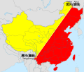
File:Heihe-tengchong-line.svg
外觀

此 SVG 檔案的 PNG 預覽的大小:705 × 599 像素。 其他解析度:282 × 240 像素 | 565 × 480 像素 | 904 × 768 像素 | 1,205 × 1,024 像素 | 2,409 × 2,048 像素 | 1,000 × 850 像素。
原始檔案 (SVG 檔案,表面大小:1,000 × 850 像素,檔案大小:216 KB)
檔案歷史
點選日期/時間以檢視該時間的檔案版本。
| 日期/時間 | 縮圖 | 尺寸 | 使用者 | 備註 | |
|---|---|---|---|---|---|
| 目前 | 2019年8月31日 (六) 08:55 |  | 1,000 × 850(216 KB) | QuYi96 | 設色改正。台灣實際未受中華人民共和國政權控制,影響人口分佈的主要社會因素大不相同,且分屬於不同脈絡;因此在人口地理學的研究及理論的適用範圍應該小心區分。 |
| 2019年8月31日 (六) 08:32 |  | 1,000 × 850(220 KB) | QuYi96 | 設色改正。台灣實際未受中華人民共和國政權控制,影響人口分佈的主要社會因素大不相同,且分屬於不同脈絡;因此在人口地理學的研究及理論的適用範圍應該小心區分。 | |
| 2016年2月14日 (日) 12:15 |  | 1,000 × 850(221 KB) | Ginbayashi | 文字图形化 | |
| 2016年2月14日 (日) 12:13 |  | 1,000 × 850(200 KB) | Ginbayashi | 更新地图及文字标注 | |
| 2009年9月4日 (五) 13:58 |  | 728 × 608(28 KB) | PhiLiP | The definition of Heihe-Tengchong-line defined by Hu Huanyong at 1987 contains Taiwan as a part of China but exclude Mongolia. | |
| 2009年8月19日 (三) 05:13 |  | 728 × 608(29 KB) | Jjhcap99 | Reverted to version as of 07:10, 11 May 2009 | |
| 2009年5月13日 (三) 23:18 |  | 728 × 608(28 KB) | Shibo77 | Reverted to version as of 01:47, 24 April 2009 黑腾线的面积、人口数据包括台澎金马 | |
| 2009年5月11日 (一) 07:10 |  | 728 × 608(29 KB) | Jjhcap99 | Reverted to version as of 01:30, 12 July 2008 | |
| 2009年4月24日 (五) 01:47 |  | 728 × 608(28 KB) | Shibo77 | Reverted to version as of 17:19, 8 March 2008 | |
| 2008年7月12日 (六) 01:30 |  | 728 × 608(29 KB) | Jjhcap99 | Taiwan is not part of PRC. |
檔案用途
下列3個頁面有用到此檔案:
全域檔案使用狀況
以下其他 wiki 使用了這個檔案:
- cs.wikipedia.org 的使用狀況
- de.wikipedia.org 的使用狀況
- el.wikipedia.org 的使用狀況
- en.wikipedia.org 的使用狀況
- es.wikipedia.org 的使用狀況
- eu.wikipedia.org 的使用狀況
- fr.wikipedia.org 的使用狀況
- gl.wikipedia.org 的使用狀況
- hi.wikipedia.org 的使用狀況
- hu.wikipedia.org 的使用狀況
- id.wikipedia.org 的使用狀況
- it.wikipedia.org 的使用狀況
- ja.wikipedia.org 的使用狀況
- ko.wikipedia.org 的使用狀況
- no.wikipedia.org 的使用狀況
- pt.wikipedia.org 的使用狀況
- ru.wikipedia.org 的使用狀況
- tr.wikipedia.org 的使用狀況
- uk.wikipedia.org 的使用狀況
- www.wikidata.org 的使用狀況

