
File:CountriesRecognizingKosovo.svg

此 SVG 檔案的 PNG 預覽的大小:800 × 349 像素。 其他解析度:320 × 139 像素 | 640 × 279 像素 | 1,024 × 446 像素 | 1,280 × 558 像素 | 2,560 × 1,115 像素 | 2,754 × 1,200 像素。
原始檔案 (SVG 檔案,表面大小:2,754 × 1,200 像素,檔案大小:1.06 MB)

摘要
| 描述 |
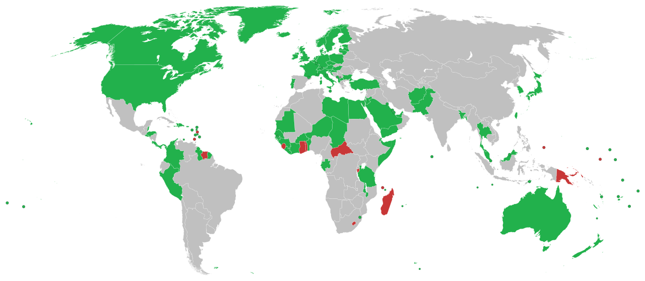
English: This is a map of countries recognizing independence of Kosovo
Recognise Kosovo as independent The region of Kosovo Withdrawn recognition Hrvatski: Ovo je karta koja prikazuje države koje su priznale neovisnost Kosova
Priznaju neovisnost Kosova Español: Mapa de los países que reconocen la independencia de Kosovo
Deutsch: Länder in Grün erkennen den Kosovo als unabhängigen Staat an. Länder in rot haben die Anerkennung zurückgezogen.
Italiano: Mappa dei paesi che hanno riconosciuto l'indipendenza del Kosovo.
Português: Mapa dos países que reconhecem a independência do Kosovo.
Română: Aceasta este o hartă care arată recunoașterea independenței Republicii Kosovo pe plan internațional
Svenska: En karta över länder som formellt erkänner Kosovos självständighetsförklaring
Formellt erkänner Kosovos självständighetsförklaring Återkallat erkännande Türkçe: Kosova'nın bağımsızlığını tanıyan ülkelerin haritası
Українська: Карта країн, що визнають незалежність Косова.
العربية: هذه خريطة الدول التي تعترف بكوسوفو كدولة مستقلة الدول التي تعترف بكوسوفو كدولة مستقلة الدول التي سحبت اعترافها بكوسوفو كدولة مستقلة الدول التي لا تعترف بكوسوفو كدولة مستقلة |
| 日期 |
2008年9月17日 (原始上傳日期) |
| 來源 |
English Wikipedia http://en.wikipedia.org/wiki/Image:CountriesRecognizingKosovo.png (Original text: March-May 2008 and ongoing) |
| 作者 | Alethiareg, ArturM, Balfabio, Avala, Mareklug, Cradel, Gugganij, Husond, en, Zscout370, en, Chech Explorer, Camptown, Hoshie, Nightstallion, Ijanderson977 / 原上傳者為英文維基百科的Alethiareg |
| 其他版本 | CountriesRecognizingKosovo.png |
| SVG開發 | 本vector image使用不明SVG工具創作。 |
授權條款
| 此作品已由其作者,英文維基百科的Alethiareg,釋出至公有領域。此授權條款在全世界均適用。 這可能在某些國家不合法,如果是的話: Alethiareg授予任何人有權利使用此作品於任何用途,除受法律約束外,不受任何限制。 |
原始上傳日誌
Transferred from en.wikipedia to Commons by EmilJ using CommonsHelper.
The original description page was here. All following user names refer to en.wikipedia.
- 14:22, 17 September 2008 940×415 (1.45 MB) EmilJ add Taiwan, omit circles for dependent territories
- 11:46, 16 September 2008 940×415 (1.45 MB) EmilJ Samoa recognized
- 14:20, 15 September 2008 940×415 (1.45 MB) EmilJ use CSS, add missing countries and territories
- 09:39, 15 September 2008 940×415 (1.49 MB) Alethiareg == Summary == {{Information |Description=This is a map of countries recognizing independence of Kosovo. |Author =User:Alethiareg, User:ArturM, User:Balfabio, [[User:Av
檔案歷史
點選日期/時間以檢視該時間的檔案版本。
| 日期/時間 | 縮圖 | 尺寸 | 使用者 | 備註 | |
|---|---|---|---|---|---|
| 目前 | 2025年4月16日 (三) 15:34 | | 2,754 × 1,200(1.06 MB) | Bar.Yardeni202 | Updated Ghana + fixed Suriname-French Guiana border |
| 2025年4月13日 (日) 08:20 |  | 2,754 × 1,200(1.06 MB) | Bar.Yardeni202 | Adding Suriname | |
| 2025年4月13日 (日) 02:36 |  | 2,754 × 1,200(1.11 MB) | Knightoftheswords281 | Including Sudanese recognition | |
| 2025年3月29日 (六) 19:48 |  | 2,754 × 1,200(1.11 MB) | MSG17 | Updated per File talk:CountriesRecognizingKosovo.svg#Map requires update (as of 27.03.2025) // Editing SVG source code using c:User:Rillke/SVGedit.js | |
| 2025年3月29日 (六) 09:16 |  | 2,754 × 1,200(1.11 MB) | MSG17 | Adding Kenya https://www.reuters.com/world/europe/kenya-recognises-kosovo-independent-state-first-such-move-five-years-2025-03-26/ // Editing SVG source code using c:User:Rillke/SVGedit.js | |
| 2022年1月1日 (六) 23:54 |  | 2,754 × 1,200(1.11 MB) | Kwamikagami | color integral constituents (Puerto Rico, New Caledonia, etc.) | |
| 2021年4月26日 (一) 21:23 |  | 2,754 × 1,200(1.05 MB) | NordNordWest | Reverted to version as of 06:02, 25 February 2021 (UTC) | |
| 2021年4月25日 (日) 16:58 |  | 512 × 223(805 KB) | ויקי4800 | תיקון גבולות מדינת ישראל | |
| 2021年2月25日 (四) 06:02 |  | 2,754 × 1,200(1.05 MB) | Liggliluff | Replacing file with BlankMap-World.svg for a better look, countries coloured by the style-code, should be correct to the last map, the image is cropped and ocean hidden, micro-nations have circles, and hovering shows popups | |
| 2021年2月8日 (一) 23:55 |  | 1,650 × 750(918 KB) | Arianasmithy74 | Reverted to version as of 21:31, 29 December 2020 (UTC) |
檔案用途
全域檔案使用狀況
以下其他 wiki 使用了這個檔案:
- af.wikipedia.org 的使用狀況
- ar.wikipedia.org 的使用狀況
- arz.wikipedia.org 的使用狀況
- ast.wikipedia.org 的使用狀況
- bg.wikipedia.org 的使用狀況
- bn.wikipedia.org 的使用狀況
- ca.wikipedia.org 的使用狀況
- cs.wikipedia.org 的使用狀況
- de.wikipedia.org 的使用狀況
- Benutzer:Generator
- Geschichte des Kosovo
- Liste der Gebiete mit begrenzter Anerkennung als Staat
- Kosovo
- Portal:Kosovo/Artikel des Monats
- Diskussion:Kosovo/Archiv/005
- Internationale Anerkennung des Kosovo
- Diskussion:Kosovo/Archiv/006
- Diskussion:Internationale Anerkennung des Kosovo/Archiv
- Wikipedia:Kartenwerkstatt/Archiv/2018-03
- el.wikipedia.org 的使用狀況
- en.wikipedia.org 的使用狀況
- es.wikipedia.org 的使用狀況
- fa.wikipedia.org 的使用狀況
- fi.wikipedia.org 的使用狀況
- fr.wikipedia.org 的使用狀況
- gl.wikipedia.org 的使用狀況
- he.wikipedia.org 的使用狀況
- hr.wikipedia.org 的使用狀況
檢視此檔案的更多全域使用狀況。