
File:Cidade City Djibouti Africa - Bases Militares China USA (29934552898).jpg
預覽大小:599 × 599 像素。 其他解析度:240 × 240 像素 | 480 × 480 像素 | 768 × 768 像素 | 1,024 × 1,024 像素 | 2,047 × 2,048 像素 | 2,879 × 2,880 像素。
原始檔案 (2,879 × 2,880 像素,檔案大小:1.37 MB,MIME 類型:image/jpeg)
.jpg?uselang=zh-tw)
.jpg?uselang=zh-tw)
.jpg?action=history&uselang=zh-tw)
.jpg)
摘要
| 描述 |
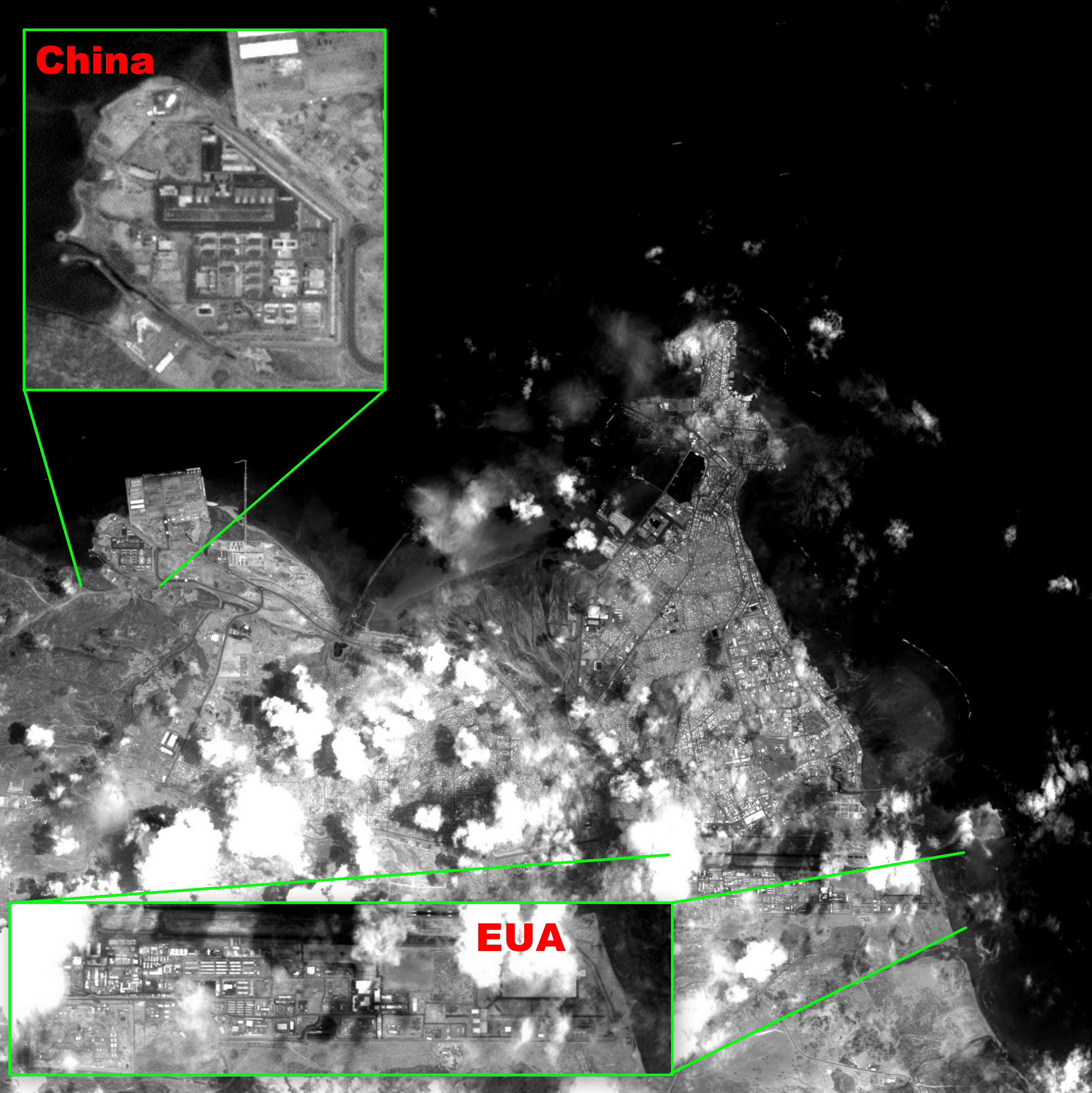
Português: Imagem CBERS4 PAN de alta resolução espacial (5m/pixel), gravada a bordo, da Cidade do Djibouti. Anotada para mostrar a proximidade, 12 km, e detalhes das bases militares Chinesa e Americana. Destacadas em resolução plena a nova base militar Chinesa, única fora da China, vizinha ao Porto de Doraleh, e a base militar Americana Camp Lemonnier, única na África, ao Sul do Aeroporto Internacional Ambouli. Assim como os EUA, França e Japão também tem bases militares no país. É um local geopoliticamente estratégico por ser localizado próximo ao Estreito Babelmândebe, já imageado aqui. Entrada no Mar Vermelho, por onde passam 5 milhões de barris de petróleo por dia com destino à Europa e Estados Unidos, via Canal de Suez. Imagem em P&B por ter apenas uma banda espectral; de 0,51 a 0,85 µm (verde ao começo do infra-vermelho próximo)
Imagem CBERS4 PAN5m Bases Militares Chinesa e Americana, Cidade do Djibouti, Africa Coordenadas do centro da imagem: 11°35'03.3"N 43°07'08.1"E Data: 13-04-2018 / 2018-13-04 P&B Cena: 070 / 087 Autor: Oton Barros (DSR/OBT/INPE)English: Djibouti City high spatial resolution (5m/pixel) recorded on board CBERS4 PAN image; illustrated to show how near, 7 miles, Chinese and American military bases are, and some of their details. Shown in full resolution, China´s new base, only outside China, besides Doraleh Port, and American base Camp Lemonnier, only in Africa, South of Ambouli Internacional Airport. Like the US, France and Japan also got military bases there. Near Bab-el-Mandeb Strait, already imaged here, it´s a geopolically strategic spot, Red Sea entrance, where 5 million oil barrels a day pass going to Europe and US via Suez Canal. Image in B&W since it has only one spectral band from 0.51 to 0.85 µm (green to near infrared).
Image CBERS4 PAN5m Bases Militares Chinesa e Americana, Cidade do Djibouti, Africa Image center: 11°35'03.3"N 43°07'08.1"E Date: 13-04-2018 / 2018-13-04 B&W Scene: 070 / 087 Author: Oton Barros (DSR/OBT/INPE) |
| 日期 | |
| 來源 | Cidade/City Djibouti/Africa - Bases Militares China / USA |
| 作者 | Coordenação-Geral de Observação da Terra/INPE |
授權條款
此檔案採用創用CC 姓名標示-相同方式分享 2.0 通用版授權條款。
- 您可以自由:
- 分享 – 複製、發佈和傳播本作品
- 重新修改 – 創作演繹作品
- 惟需遵照下列條件:
- 姓名標示 – 您必須指名出正確的製作者,和提供授權條款的連結,以及表示是否有對內容上做出變更。您可以用任何合理的方式來行動,但不得以任何方式表明授權條款是對您許可或是由您所使用。
- 相同方式分享 – 若要根據本素材進行再混合、轉換或創作,則必須以與原作相同或相容的授權來發布您的作品。
| 這幅圖片原始出處為Flickr的https://flickr.com/photos/153282474@N02/29934552898 ,作者為Coordenação-Geral de Observação da Terra/INPE 。經機器人FlickreviewR 2在2020年10月12日審查後確定為採用cc-by-sa-2.0的協議授權使用。 |
檔案歷史
點選日期/時間以檢視該時間的檔案版本。
| 日期/時間 | 縮圖 | 尺寸 | 使用者 | 備註 | |
|---|---|---|---|---|---|
| 目前 | 2020年10月12日 (一) 05:07 | | 2,879 × 2,880(1.37 MB) | Sturm | Transferred from Flickr via #flickr2commons |
檔案用途
下列頁面有用到此檔案:
全域檔案使用狀況
以下其他 wiki 使用了這個檔案:
- ca.wikipedia.org 的使用狀況
- fi.wikipedia.org 的使用狀況
- fr.wikipedia.org 的使用狀況
- he.wikipedia.org 的使用狀況
- www.wikidata.org 的使用狀況
.jpg)