
File:Accreting coast Image6.svg

此 SVG 檔案的 PNG 預覽的大小:800 × 377 像素。 其他解析度:320 × 151 像素 | 640 × 301 像素 | 1,024 × 482 像素 | 1,280 × 602 像素 | 2,560 × 1,205 像素 | 1,481 × 697 像素。
原始檔案 (SVG 檔案,表面大小:1,481 × 697 像素,檔案大小:15 KB)
摘要
| 描述 |
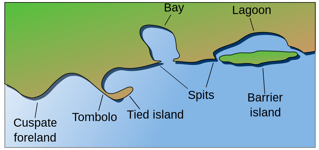
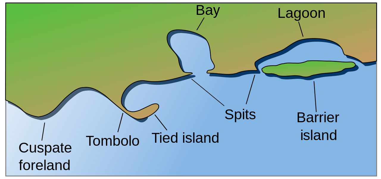
English: Coastal and oceanic landforms. Cuspate foreland, tombolo, spit, bay, lagoon, barrier island. |
| 日期 | |
| 來源 | self-made SVG, based on the public domain PNG Accreting coast Image6.png by Feydey |
| 作者 | Surachit |
| 其他版本 |
Derivative works of this file: Accreting coast Image6-ta.svg
|
| SVG開發 | 本vector image使用Inkscape創作,或使用了其他工具。 |


授權條款
| 此作品已由其作者,Feydey,釋出至公有領域。此授權條款在全世界均適用。 這可能在某些國家不合法,如果是的話: |
檔案歷史
點選日期/時間以檢視該時間的檔案版本。
| 日期/時間 | 縮圖 | 尺寸 | 使用者 | 備註 | |
|---|---|---|---|---|---|
| 目前 | 2022年5月16日 (一) 04:17 | | 1,481 × 697(15 KB) | Bacon Noodles | Fixed background (water) alignment |
| 2018年2月12日 (一) 01:49 |  | 1,481 × 697(15 KB) | Howpper | Added tied island. A Tombolo is what connects a Tied island to the mainland, so it would be exclusive to not include both features. | |
| 2007年8月16日 (四) 21:48 |  | 1,481 × 697(13 KB) | Surachit | {{Information |Description=Coastal and oceanic landforms. Cuspate foreland, tombolo, spit, bay, lagoon, barrier island. |Source=self-made SVG, based on the public domain PNG [http://en.wikipedia.org/wiki/Image:Accreting_coast_Image6.png] by [http://en.wik |
檔案用途
下列61個頁面有用到此檔案:
- 三角洲
- 半岛
- 吹蝕穴
- 地峡
- 大陆坡
- 大陆架
- 天然拱
- 小灣
- 岛礁
- 岸
- 峡湾
- 島嶼
- 广湾
- 悬崖
- 暗礁
- 水道
- 沙丘
- 沙嘴
- 沙洲
- 河口灣
- 沿岸流
- 波濤
- 海下水蝕洞
- 海岸侵蝕
- 海岸平原
- 海岸管理
- 海峡
- 海底峽谷
- 海灘地形動力學
- 海灣
- 海蚀柱
- 海蝕平臺
- 海蝕洞
- 海蝕隙
- 海角
- 淡水沼澤
- 溺灣
- 滩涂
- 潟湖
- 潮汐島
- 潮池
- 潮間帶
- 灘
- 火山弧
- 珊瑚礁
- 環礁
- 礁
- 群島
- 芦苇属
- 苦鹹水沼澤
- 連島沙洲
- 陸連島
- 離岸流
- 離水海岸
- 鵝卵石海灘
- 鹽鹼灘
- User:台北人/沙盒/沙盒12
- Wikipedia:臺灣教育專案/輕鬆上手!維基百科編輯入門/沿海平原
- Template:海岸地理
- Template:海岸管理
- Draft:顆粒 (地質學)
全域檔案使用狀況
以下其他 wiki 使用了這個檔案:
- ar.wikipedia.org 的使用狀況
- az.wikipedia.org 的使用狀況
- bh.wikipedia.org 的使用狀況
- bn.wikipedia.org 的使用狀況
- chr.wikipedia.org 的使用狀況
- cs.wikipedia.org 的使用狀況
- en.wikipedia.org 的使用狀況
檢視此檔案的更多全域使用狀況。