
File:1800 Wilkinson Map of the 4 Eastern Churches rectified.jpg

預覽大小:769 × 599 像素。 其他解析度:308 × 240 像素 | 616 × 480 像素 | 985 × 768 像素 | 1,280 × 998 像素 | 1,678 × 1,308 像素。
原始檔案 (1,678 × 1,308 像素,檔案大小:895 KB,MIME 類型:image/jpeg)
| 描述 |
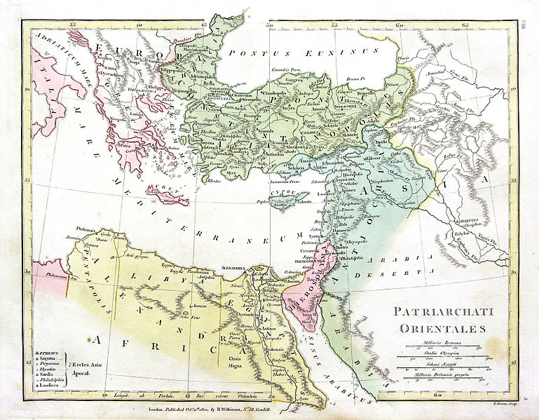
English: Map of the 4 Eastern Churches in the Pentarchy, circa 500CE |
| 日期 | (UTC) |
| 來源 | |
| 作者 |
原上傳者為英文維基百科的Fredrick Wilhelm
|
| 這是一張修飾過的圖片,即本圖片是用軟體修改過後的版本,修改的方式或內容有:Rectified, cropped, colors corrected。原版圖片來源:1800 Wilkinson Map of the 4 Eastern Churches.jpg。修改者:MichaelBueker。
|
|
本作品在其來源國以及其他著作權期限是作者逝世後70年或以下的國家與地區屬於公有領域。 | |
| 此作品無已知的著作權限制,亦不受所有相關和鄰接的權利限制。 | |
原始上傳日誌
This image is a derivative work of the following images:
- File:1800_Wilkinson_Map_of_the_4_Eastern_Churches.jpg licensed with Cc-pd-mark-footer, PD-old
- 2010-08-24T08:50:03Z File Upload Bot (Magnus Manske) 1802x1378 (2039705 Bytes) {{BotMoveToCommons|en.wikipedia|year={{subst:CURRENTYEAR}}|month={{subst:CURRENTMONTHNAME}}|day={{subst:CURRENTDAY}}}} {{Information |Description={{en|Map of the 4 Eastern Churches in the Pentarchy, circa 500CE}} |Source=Tra
Uploaded with derivativeFX
檔案歷史
點選日期/時間以檢視該時間的檔案版本。
| 日期/時間 | 縮圖 | 尺寸 | 使用者 | 備註 | |
|---|---|---|---|---|---|
| 目前 | 2016年2月10日 (三) 20:47 | | 1,678 × 1,308(895 KB) | Чръный человек | обработка |
| 2016年2月9日 (二) 18:04 |  | 1,678 × 1,308(1.22 MB) | Чръный человек | Осветление | |
| 2011年5月1日 (日) 20:29 |  | 1,678 × 1,308(1.91 MB) | MichaelBueker | color touchup | |
| 2011年5月1日 (日) 20:14 |  | 1,678 × 1,308(1.61 MB) | MichaelBueker | {{Information |Description={{en|Map of the 4 Eastern Churches in the Pentarchy, circa 500CE}} |Source=*File:1800_Wilkinson_Map_of_the_4_Eastern_Churches.jpg |Date=2011-05-01 20:13 (UTC) |Author=*[[:File:1800_Wilkinson_Map_of_the_4_Eastern_Churches.j |
檔案用途
下列頁面有用到此檔案:
全域檔案使用狀況
以下其他 wiki 使用了這個檔案:
- ar.wikipedia.org 的使用狀況
- arz.wikipedia.org 的使用狀況
- az.wikipedia.org 的使用狀況
- bg.wikipedia.org 的使用狀況
- bn.wikipedia.org 的使用狀況
- ckb.wikipedia.org 的使用狀況
- cs.wikipedia.org 的使用狀況
- el.wikipedia.org 的使用狀況
- en.wikipedia.org 的使用狀況
- eo.wikipedia.org 的使用狀況
- es.wikipedia.org 的使用狀況
- fa.wikipedia.org 的使用狀況
- fr.wikipedia.org 的使用狀況
- hu.wikipedia.org 的使用狀況
- id.wikipedia.org 的使用狀況
- it.wikipedia.org 的使用狀況
- ko.wikipedia.org 的使用狀況
- mk.wikipedia.org 的使用狀況
- ml.wikipedia.org 的使用狀況
- pt.wikipedia.org 的使用狀況
- ru.wikipedia.org 的使用狀況
- sk.wikipedia.org 的使用狀況
- sr.wikipedia.org 的使用狀況
- sv.wikipedia.org 的使用狀況
- tr.wikipedia.org 的使用狀況
- uk.wikipedia.org 的使用狀況
檢視此檔案的更多全域使用狀況。