
File:Qing China 1820.png
預覽大小:800 × 593 像素。 其他解析度:320 × 237 像素 | 640 × 475 像素 | 910 × 675 像素。
原始檔案 (910 × 675 像素,檔案大小:327 KB,MIME 類型:image/png)
| 描述 |
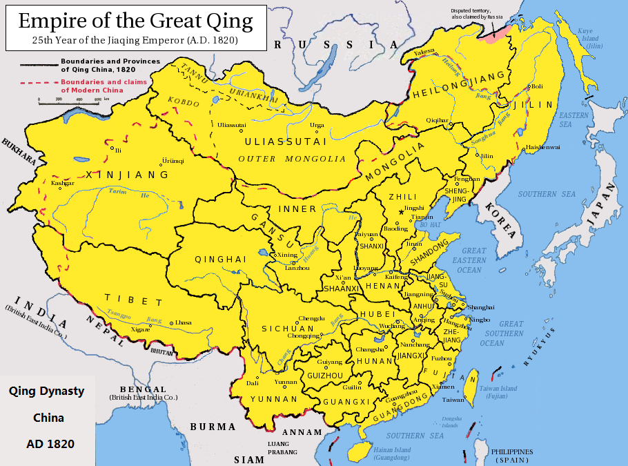
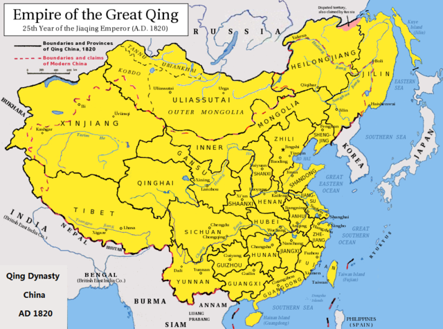
English: Map of the Qing Dynasty China in 1820. (Includes provincial boundaries and the boundaries of modern China for reference.) Adapted from http://en.wikipedia.org/wiki/Image:ROC_PRC_comparison_eng.jpg and information complied from other sources such as http://baike.baidu.com/view/5405.htm , http://map.huhai.net/58-59.jpg and http://www.sina7.com/jdwh/UploadFiles_6109/200709/20070918093610860.jpg 中文(简体):大清嘉庆二十五年疆域图。 中文(繁體):大清嘉慶廿五年疆域圖。 日本語: 大清の嘉慶25年の疆域の図。 Tiếng Việt: Đại Thanh bản đồ (1820). |
| 日期 | (UTC) |
| 來源 |
|
| 作者 |
|
| 這是一張修飾過的圖片,即本圖片是用軟體修改過後的版本,修改的方式或內容有:border islands。原版圖片來源:Qing Dynasty 1820.png。
|
我,本作品的著作權持有者,決定用以下授權條款發佈本作品:
此檔案採用共享創意 姓名標示-相同方式分享 3.0 未在地化版本授權條款。
- 您可以自由:
- 分享 – 複製、發佈和傳播本作品
- 重新修改 – 創作演繹作品
- 惟需遵照下列條件:
- 姓名標示 – 您必須指名出正確的製作者,和提供授權條款的連結,以及表示是否有對內容上做出變更。您可以用任何合理的方式來行動,但不得以任何方式表明授權條款是對您許可或是由您所使用。
- 相同方式分享 – 如果您利用本素材進行再混合、轉換或創作,您必須基於如同原先的相同或兼容的條款,來分布您的貢獻成品。

|
已授權您依據自由軟體基金會發行的無固定段落、封面文字和封底文字GNU自由文件授權條款1.2版或任意後續版本,對本檔進行複製、傳播和/或修改。該協議的副本列在GNU自由文件授權條款中。 |
您可以選擇您需要的授權條款。
原始上傳日誌
This image is a derivative work of the following images:
- File:Qing_Dynasty_1820.png licensed with Cc-by-sa-3.0, GFDL
- 2010-06-22T03:48:22Z Benlisquare 910x675 (363965 Bytes) Revert - redraw the map yourself. MS Paint overlaying of a corner is an eyesore. Illogical to have the title repeated twice.
- 2010-06-21T21:46:33Z Hisacw 910x675 (395648 Bytes) rv to NPOVify: the status on certain outlier islands (e.g. Sakhalin) is not explicitly defined, c.f. the map [http://go-passport.grolier.com/map?id=mh00032&pid=go]
- 2010-06-20T05:59:11Z Benlisquare 910x675 (363965 Bytes) Reverted to version as of 19:58, 27 September 2008
- 2010-06-20T05:58:44Z Benlisquare 910x675 (363965 Bytes) possible POV vandal
- 2010-06-19T05:34:53Z Hisacw 910x675 (395648 Bytes) small adj from original
- 2008-10-15T02:32:20Z Pryaltonian 910x675 (363965 Bytes) Reverted to version as of 19:58, 27 September 2008
- 2008-10-15T02:29:27Z Pryaltonian 910x675 (400039 Bytes) [[Category:China]] [[Category:Taiwan]] [[Category:Tibet]] [[Category:Mongolia]]
- 2008-09-27T19:58:02Z Pryaltonian 910x675 (363965 Bytes) {{Information |Description={{en|1=Map of the Qing Dynasty at its greatest extent. Includes provincial boundaries and the boundaries of modern China for reference.}} |Source=Own work by uploader |Author=[[User:Pryaltonian|Pry
Uploaded with derivativeFX
檔案歷史
點選日期/時間以檢視該時間的檔案版本。
| 日期/時間 | 縮圖 | 尺寸 | 用戶 | 備註 | |
|---|---|---|---|---|---|
| 目前 | 2020年2月23日 (日) 06:02 | | 910 × 675(327 KB) | Morrisonjohn022 | Reverted to version as of 17:00, 23 July 2011 (UTC) While the indigenous peoples of Sakhalin was not Han Chinese, Sakhalin was claimed by the Qing Empire and it was recognized as such by other countries (until the 1858 Treaty of Aigun and 1860 Treaty of Peking gave the island to Russia). See p. 11 of "Restless Empire: China and the World Since 1750" by Odd Arne Westad, p. 200 of "Ethnic Groups of North, East, and Central Asia: An Encyclopedia" by James B. Minahan, and p. 2 of "Across Forest,... |
| 2019年10月26日 (六) 12:35 |  | 910 × 675(386 KB) | Artanisen | Reverted to version as of 22:40, 24 October 2010 (UTC) Sakhalin was not Chinese. It was first occupied by the indigenous Ainu people and later it became half Japanese (Karafuto) and Russian (Sakhalin) then it became wholly part of the Russian Federation after WW2 | |
| 2011年7月23日 (六) 17:00 |  | 910 × 675(327 KB) | Shibo77 | .. | |
| 2010年10月24日 (日) 22:40 |  | 910 × 675(386 KB) | Wengier | minor | |
| 2010年10月24日 (日) 22:35 |  | 910 × 675(386 KB) | Wengier | {{Information |Description={{en|1=Map of the Qing Dynasty China in 1820. (Includes provincial boundaries and the boundaries of modern China for reference.)<br/>Adapted from http://en.wikipedia.org/wiki/Image:ROC_PRC_comparison_eng.jpg and information comp |
檔案用途
下列頁面有用到此檔案:
全域檔案使用狀況
以下其他 wiki 使用了這個檔案:
- bcl.wikipedia.org 的使用狀況
- be.wikipedia.org 的使用狀況
- bn.wikipedia.org 的使用狀況
- en.wikipedia.org 的使用狀況
- hi.wikipedia.org 的使用狀況
- ml.wikipedia.org 的使用狀況
- pl.wikipedia.org 的使用狀況
- pnb.wikipedia.org 的使用狀況
- ru.wikipedia.org 的使用狀況
- tl.wikipedia.org 的使用狀況
- ur.wikipedia.org 的使用狀況