
File:MetroLink map (article version).svg

此 SVG 檔案的 PNG 預覽的大小:800 × 167 像素。 其他解析度:320 × 67 像素 | 640 × 133 像素 | 1,024 × 213 像素 | 1,280 × 266 像素 | 2,560 × 533 像素 | 1,936 × 403 像素。
原始檔案 (SVG 檔案,表面大小:1,936 × 403 像素,檔案大小:407 KB)
.svg?uselang=zh-mo)
.svg?uselang=zh-mo)
.svg?action=history&uselang=zh-mo)
.svg)
摘要
| 描述 |
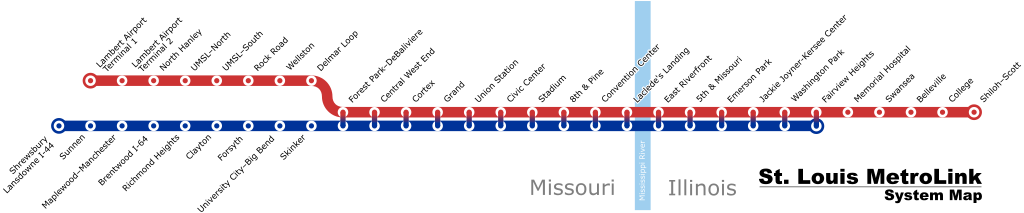
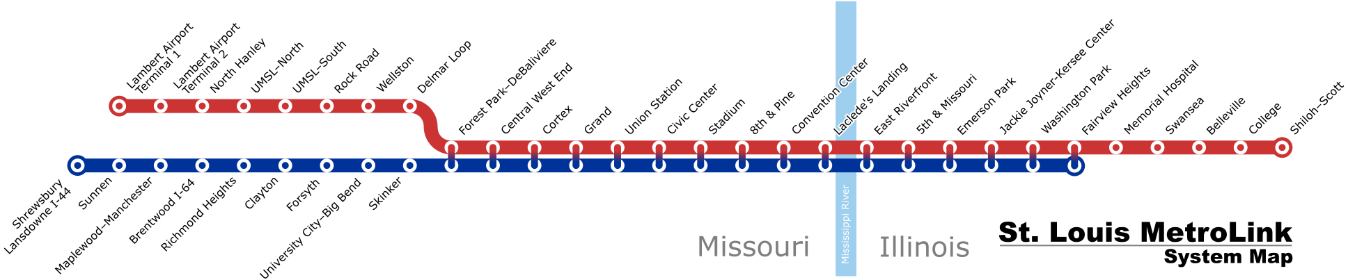
English: A schematic map of the the St. Louis MetroLink system as of August 2018 |
| 日期 | (latest version) |
| 來源 | 自己的作品 |
| 作者 | Millbrooky |
| 其他版本 |
 |
授權條款
我,本作品的著作權持有者,決定用以下授權條款發佈本作品:
此檔案採用共享創意 姓名標示-相同方式分享 3.0 未在地化版本授權條款。
- 您可以自由:
- 分享 – 複製、發佈和傳播本作品
- 重新修改 – 創作演繹作品
- 惟需遵照下列條件:
- 姓名標示 – 您必須指名出正確的製作者,和提供授權條款的連結,以及表示是否有對內容上做出變更。您可以用任何合理的方式來行動,但不得以任何方式表明授權條款是對您許可或是由您所使用。
- 相同方式分享 – 若要根據本素材進行再混合、轉換或創作,則必須以與原作相同或相容的授權來發布您的作品。
檔案歷史
點選日期/時間以檢視該時間的檔案版本。
| 日期/時間 | 縮圖 | 尺寸 | 用戶 | 備註 | |
|---|---|---|---|---|---|
| 目前 | 2019年4月2日 (二) 14:29 | 1,936 × 403(407 KB) | Dream out loud | extended Blue Line to Fairview Heights | |
| 2019年2月21日 (四) 12:23 | 1,936 × 403(392 KB) | Dream out loud | fixed station names, changed appearance of Red/Blue shared stations | ||
| 2018年8月11日 (六) 19:39 | 1,925 × 380(473 KB) | Pi.1415926535 | update for Cortex station opening | ||
| 2015年3月9日 (一) 23:57 | 1,920 × 460(390 KB) | Dream out loud | updated Laclede's Landing station name | ||
| 2015年2月1日 (日) 21:21 | 1,920 × 460(385 KB) | Dream out loud | |||
| 2008年10月31日 (五) 21:20 | 1,920 × 460(484 KB) | Millbrooky | one last revision to make text slightly larger | ||
| 2008年10月29日 (三) 17:57 | 1,885 × 400(492 KB) | Millbrooky | {{Information |Description= |Source= |Date= |Author= |Permission= |other_versions= }} | ||
| 2008年10月28日 (二) 15:53 | 1,885 × 400(72 KB) | Millbrooky | {{Information |Description={{en|1=A schematic map of the the St. Louis MetroLink system as of October 27, 2008.}} |Source=Own work by uploader |Author=Millbrooky |Date=2008 |Permission= |other_versions=MetroLink map.svg }} <!--{{Image |
檔案用途
下列頁面有用到此檔案:
全域檔案使用狀況
以下其他 wiki 使用了這個檔案:
- cy.wikipedia.org 的使用狀況
- de.wikipedia.org 的使用狀況
- en.wikipedia.org 的使用狀況
- fr.wikipedia.org 的使用狀況
- he.wikivoyage.org 的使用狀況
- ru.wikipedia.org 的使用狀況
- uk.wikipedia.org 的使用狀況
- www.wikidata.org 的使用狀況
.svg)