
File:Eq-prob.jpg
預覽大小:448 × 600 像素。 其他解析度:179 × 240 像素 | 535 × 716 像素。
原始檔案 (535 × 716 像素,檔案大小:150 KB,MIME 類型:image/jpeg)
摘要
| 描述 |
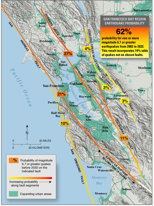
English: USGS seismic hazard map showing the probability of an M6.7 or greater earthquake occurring in the San Francisco Bay Area between 2003 and 2032.
Recent (January 2008) assessments (San Jose Mercury News: Hayward fault might be more dangerous than scientists thought ) suggest that the Hayward, Rodgers Creek, and northern Calaveras faults may be more likely to fail in the next few decades than previously thought (more so than is indicated on this map). |
| 來源 | https://pubs.usgs.gov/fs/old.2003/fs039-03/ |
| 作者 |
授權條款
|
|
原始上傳日誌
The original description page was here. All following user names refer to en.wikipedia.
- 2005-05-04 07:16 RockBandit 535×716×8 (153090 bytes) [[USGS]] seismic hazard map showing the probability of a M6.7 or greater earthquake occuring in the [[San Francisco Bay Area]] between [[2003]] and [[2032]]. {{PD-USGov-Interior-USGS}}
檔案歷史
點選日期/時間以檢視該時間的檔案版本。
| 日期/時間 | 縮圖 | 尺寸 | 用戶 | 備註 | |
|---|---|---|---|---|---|
| 目前 | 2008年5月13日 (二) 20:21 | | 535 × 716(150 KB) | Satipatthana | {{Information |Description={{en|en:USGS seismic hazard map showing the probability of an M6.7 or greater earthquake occurring in the en:San Francisco Bay Area between en:2003 and en:2032. Recent (January 2008) assessments (San Jose Me |
檔案用途
下列頁面有用到此檔案:
全域檔案使用狀況
以下其他 wiki 使用了這個檔案:
- ar.wikipedia.org 的使用狀況
- de.wikipedia.org 的使用狀況
- en.wikipedia.org 的使用狀況
- en.wikibooks.org 的使用狀況
- es.wikipedia.org 的使用狀況
- gl.wikipedia.org 的使用狀況
- id.wikipedia.org 的使用狀況
- it.wikibooks.org 的使用狀況
- it.wikiversity.org 的使用狀況
- la.wikipedia.org 的使用狀況
- www.wikidata.org 的使用狀況