
File:ROC vs PRC.svg

此 SVG 檔案的 PNG 預覽的大小:512 × 351 像素。 其他解析度:320 × 219 像素 | 640 × 439 像素 | 1,024 × 702 像素 | 1,280 × 878 像素 | 2,560 × 1,755 像素。
原始檔案 (SVG 檔案,表面大小:512 × 351 像素,檔案大小:1.35 MB)
摘要
| 描述 |
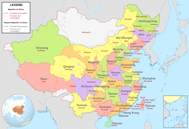
English: Comparison between Republic of China (1953-2002 in Taiwan) and People's Republic of China administrative divisions.
Adapted from File:ROC PRC comparison eng.jpg. The original ROC map included more cities, but the adaptation removed non-central municipalities to clean up the image. Therefore, this image contains: Republic of China
People's Republic of China
|
| 日期 | |
| 來源 |
我個人以下列物件為基礎來創作: China (+claims, +Hainan), administrative divisions - Blank - colored.svg |
| 作者 | Milenioscuro |
| 其他版本 |
|
.svg)

,_administrative_divisions_-_Blank_-_colored.svg)
授權條款
我,本作品的著作權持有者,決定用以下授權條款發佈本作品:
此檔案採用共享創意 姓名標示-相同方式分享 4.0 國際授權條款。
- 您可以自由:
- 分享 – 複製、發佈和傳播本作品
- 重新修改 – 創作演繹作品
- 惟需遵照下列條件:
- 姓名標示 – 您必須指名出正確的製作者,和提供授權條款的連結,以及表示是否有對內容上做出變更。您可以用任何合理的方式來行動,但不得以任何方式表明授權條款是對您許可或是由您所使用。
- 相同方式分享 – 若要根據本素材進行再混合、轉換或創作,則必須以與原作相同或相容的授權來發布您的作品。
- ↑ “Taiwan Veto Likely; Taipei Regime May Again Bar Outer Mongolia From U.N.”, in The New York Times[1], 22 April 1961
- ↑ 中華民國年鑑. Archived from the original on April 19, 2003. Retrieved on January 21, 2017.
檔案歷史
點選日期/時間以檢視該時間的檔案版本。
| 日期/時間 | 縮圖 | 尺寸 | 用戶 | 備註 | |
|---|---|---|---|---|---|
| 目前 | 2024年7月31日 (三) 02:56 | | 512 × 351(1.35 MB) | Lilauid | 更新邊界 |
| 2024年6月30日 (日) 02:14 |  | 512 × 351(5.63 MB) | Lilauid | 修正邊界 | |
| 2022年7月15日 (五) 05:04 |  | 1,339 × 918(1.71 MB) | Tjs2012 | Adjust borders | |
| 2021年4月11日 (日) 19:25 |  | 1,339 × 918(1.71 MB) | Milenioscuro | the color reflects the political divisions of PRC, so Taiwan must be ONE color, disputed territories in white like original file | |
| 2020年6月15日 (一) 05:36 |  | 512 × 401(1.43 MB) | Jrthsr700tmax | Add New Taipei, Taoyuan, Tainan | |
| 2020年2月15日 (六) 19:13 |  | 1,156 × 904(2.18 MB) | Milenioscuro | colors of provinces | |
| 2020年2月1日 (六) 16:53 |  | 1,156 × 904(2.18 MB) | Milenioscuro | User created page with UploadWizard |
檔案用途
下列4個頁面有用到此檔案:
全域檔案使用狀況
以下其他 wiki 使用了這個檔案:
- af.wikipedia.org 的使用狀況
- ast.wikipedia.org 的使用狀況
- az.wikipedia.org 的使用狀況
- cdo.wikipedia.org 的使用狀況
- de.wikipedia.org 的使用狀況
- en.wikipedia.org 的使用狀況
- eo.wikipedia.org 的使用狀況
- es.wikipedia.org 的使用狀況
- fr.wikipedia.org 的使用狀況
- gan.wikipedia.org 的使用狀況
- it.wikipedia.org 的使用狀況
- ja.wikipedia.org 的使用狀況
- ko.wikipedia.org 的使用狀況
- pam.wikipedia.org 的使用狀況
- ru.wikipedia.org 的使用狀況
- tr.wikipedia.org 的使用狀況