
File:British Empire in 1898.png
預覽大小:800 × 348 像素。 其他解析度:320 × 139 像素 | 640 × 278 像素 | 1,434 × 624 像素。
原始檔案 (1,434 × 624 像素,檔案大小:31 KB,MIME 類型:image/png)

|
本圖片是以PNG、GIF或JPEG格式上傳。然而,其中包含的資料或訊息,應該重新建立成可縮放向量圖形(SVG)檔案,以更有效率或更準確的方式儲存。如有可能,請上傳本圖片的SVG格式版本。在上傳之後,請修改維基各姊妹計畫中所有使用舊版圖片的條目(列在圖像連結章節中),替換為新版圖片,並在舊圖片的描述頁中加入{{Vector version available|新圖片名稱.svg}}模板,同時移除本模板。
|
摘要
| 描述 |
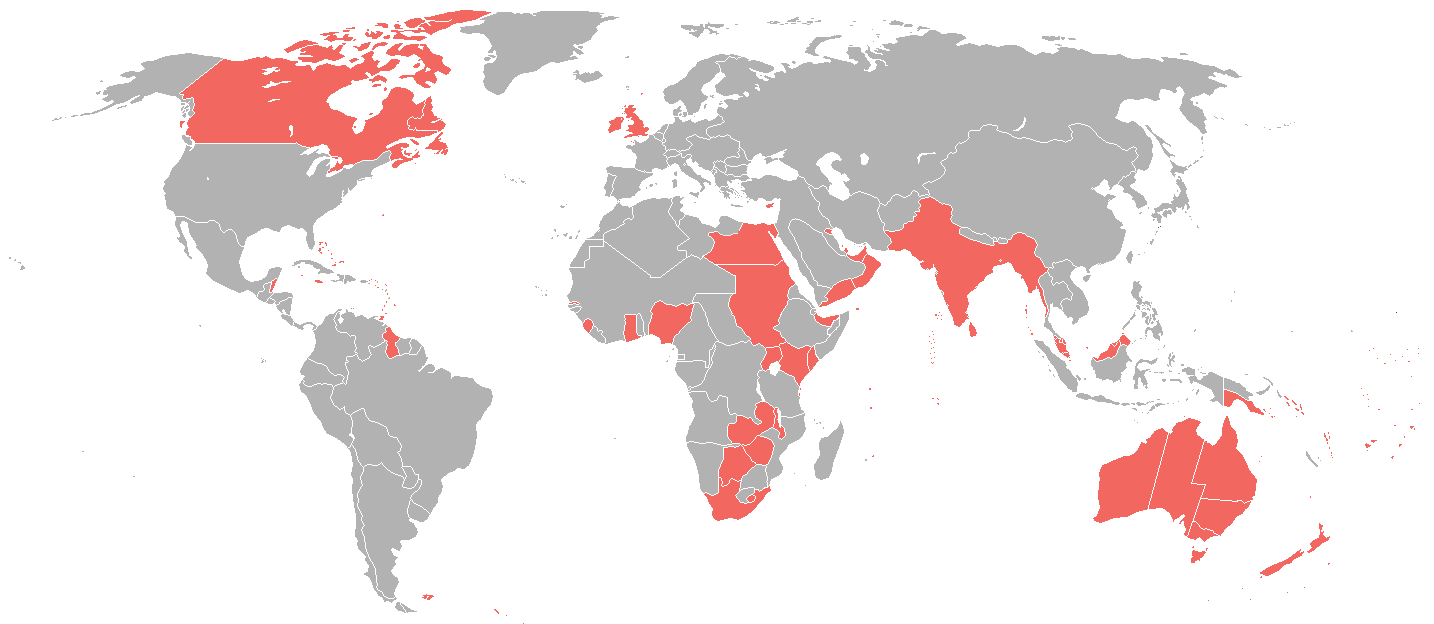
English: A map of the British Empire as it was in 1898, prior to the Second Boer War (1899-1902). |
| 日期 | |
| 來源 | File:World_1898_empires_colonies_territory.png |
| 作者 | User:Roke~commonswiki |
| 授權許可 (重用此檔案) |
File:World_1898_empires_colonies_territory.png |
授權條款
此檔案採用共享創意 姓名標示-相同方式分享 3.0 未在地化版本授權條款。
- 您可以自由:
- 分享 – 複製、發佈和傳播本作品
- 重新修改 – 創作演繹作品
- 惟需遵照下列條件:
- 姓名標示 – 您必須指名出正確的製作者,和提供授權條款的連結,以及表示是否有對內容上做出變更。您可以用任何合理的方式來行動,但不得以任何方式表明授權條款是對您許可或是由您所使用。
- 相同方式分享 – 若要根據本素材進行再混合、轉換或創作,則必須以與原作相同或相容的授權來發布您的作品。
檔案歷史
點選日期/時間以檢視該時間的檔案版本。
| 日期/時間 | 縮圖 | 尺寸 | 用戶 | 備註 | |
|---|---|---|---|---|---|
| 目前 | 2025年2月1日 (六) 17:35 | | 1,434 × 624(31 KB) | Subayerboombastic | Reverted to version as of 23:12, 23 June 2016 (UTC) |
| 2021年10月31日 (日) 08:08 |  | 1,434 × 624(39 KB) | Randomastwritter | jubaland | |
| 2016年6月23日 (四) 23:12 |  | 1,434 × 624(31 KB) | Maproom | Islands near Madagascar, which were colored blue as French territory, now grey. | |
| 2016年4月11日 (一) 22:20 |  | 1,434 × 624(38 KB) | The- | More accurate map | |
| 2015年7月7日 (二) 12:29 |  | 1,357 × 628(35 KB) | Snow Lion Fenian | {{subst:Upload marker added by en.wp UW}} {{Information |Description = {{en|A map of the British Empire as it was in 1898, prior to the Second Boer War (1899-1902).}} |Source = https://commons.wikimedia.org/wiki/File:World_1898_empires_colonies_territo... |
檔案用途
下列頁面有用到此檔案:
全域檔案使用狀況
以下其他 wiki 使用了這個檔案:
- ar.wikipedia.org 的使用狀況
- ca.wikipedia.org 的使用狀況
- cs.wikipedia.org 的使用狀況
- de.wikipedia.org 的使用狀況
- en.wikipedia.org 的使用狀況
- es.wikipedia.org 的使用狀況
- et.wikipedia.org 的使用狀況
- id.wikipedia.org 的使用狀況
- ja.wikipedia.org 的使用狀況
- ko.wikipedia.org 的使用狀況
- sk.wikipedia.org 的使用狀況
- ta.wikipedia.org 的使用狀況
- tr.wikipedia.org 的使用狀況