
File:MapTurkishProvincesNumbers.svg

此 SVG 檔案的 PNG 預覽的大小:800 × 566 像素。 其他解析度:320 × 226 像素 | 640 × 453 像素 | 1,024 × 724 像素 | 1,280 × 905 像素 | 2,560 × 1,810 像素 | 1,052 × 744 像素。
原始檔案 (SVG 檔案,表面大小:1,052 × 744 像素,檔案大小:258 KB)
摘要
| 描述 |
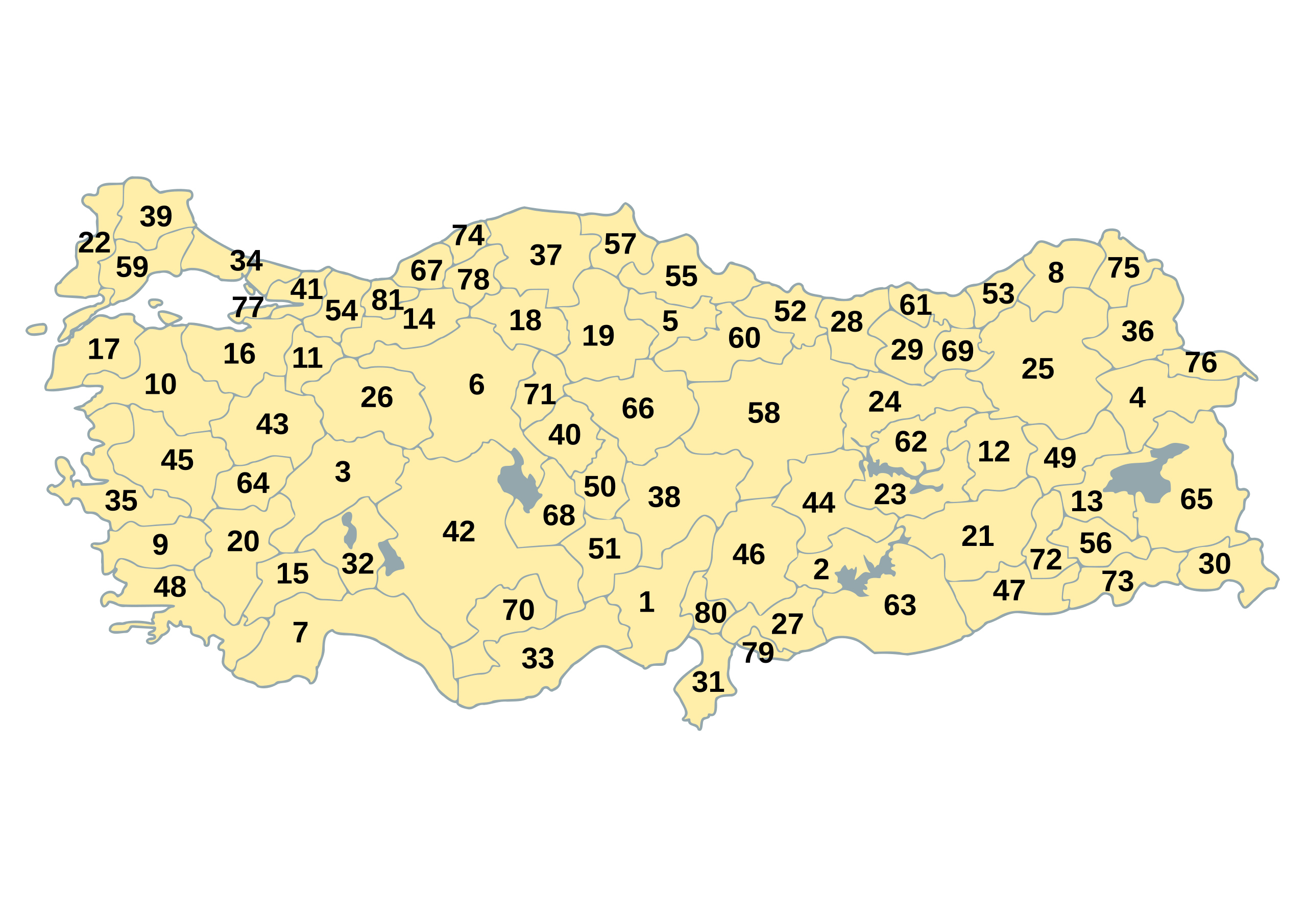
Map of Republic of Turkey's provinces, including ISO 3166-2 code numbers. These numbers are also used on Turkish car number plates. The original map is available as Image:BlankMapTurkeyProvinces.png. The author gave the following information: Description=Blank map of Republic of Turkey's provinces. The regions are carefully separated on per pixel basis and ready for filling in with a paint tool. Source=Self drawn from scratch, based on data from official Turkish motorway network map Date=December 21, 2006 Author=Atilim Gunes Baydin Permission=I grant permission for anyone to use this under the terms of GFDL license, see below |
| 日期 | 2006年12月21日 (原始上傳日期) |
| 來源 | Originally from commons.wikipedia; description page is/was here. |
| 作者 |
Modifications made by user User:Hk_kng at commons.wikipedia Original uploader was AtilimGunesBaydin at commons.wikipedia |
原始上傳日誌
(All user names refer to commons.wikipedia)
- 2007-02-18 22:14 AtilimGunesBaydin 1024×500×8 (23317 bytes) Removed Samothraki, which was accidentally included. I'm sorry for the mistake.
- 2006-12-22 16:46 AtilimGunesBaydin 1024×500×8 (23347 bytes) Slight resize.
- 2006-12-21 21:51 AtilimGunesBaydin 1024×499×8 (23338 bytes) {{Information |Description=Blank map of [[:en:Turkey|Republic of Turkey]]'s provinces |Source=Drawn from scratch on based on data from [http://www.kgm.gov.tr/images/trkh-yeni1.jpg official Turkish motorway network map] |Date=December 21, 2006 |Author=[[:e
授權條款
我,本作品的著作權持有者,決定用以下授權條款發佈本作品:

|
已授權您依據自由軟體基金會發行的無固定段落、封面文字和封底文字GNU自由文件授權條款1.2版或任意後續版本,對本檔進行複製、傳播和/或修改。該協議的副本列在GNU自由文件授權條款中。 |
| 此檔案採用創用CC 姓名標示-相同方式分享 3.0 未在地化版本授權條款。 | ||
| ||
| 已新增授權條款標題至此檔案,作為GFDL授權更新的一部份。 |
檔案歷史
點選日期/時間以檢視該時間的檔案版本。
| 日期/時間 | 縮圖 | 尺寸 | 使用者 | 備註 | |
|---|---|---|---|---|---|
| 目前 | 2015年6月3日 (三) 15:27 | | 1,052 × 744(258 KB) | Sangjinhwa | Reverted to version as of 02:48, 9 April 2007 |
| 2014年11月30日 (日) 20:57 |  | 5,000 × 2,166(10.76 MB) | Gloyacks | 영문지명 추가 | |
| 2014年10月13日 (一) 10:33 |  | 5,000 × 2,166(3.92 MB) | Gloyacks | 원작성본 올림 | |
| 2014年10月12日 (日) 19:09 |  | 2,250 × 975(1.26 MB) | Gloyacks | 재작성 | |
| 2007年4月9日 (一) 02:48 |  | 1,052 × 744(258 KB) | Hk kng | {{Information |Description=Map of Republic of Turkey's provinces, including ISO 3166-2 code numbers. These numbers are also used on Turkish car number plates. The original map is available as Image:BlankMapTurkeyProvinces.png. The aut |
檔案用途
下列頁面有用到此檔案:
全域檔案使用狀況
以下其他 wiki 使用了這個檔案:
- de.wikipedia.org 的使用狀況
- el.wikipedia.org 的使用狀況
- en.wikipedia.org 的使用狀況
- eo.wikipedia.org 的使用狀況
- fa.wikipedia.org 的使用狀況
- frr.wikipedia.org 的使用狀況
- it.wikipedia.org 的使用狀況
- ja.wikipedia.org 的使用狀況
- tr.wikipedia.org 的使用狀況
- uk.wikipedia.org 的使用狀況
- ur.wikipedia.org 的使用狀況