
File:Nepal - Sagamartha Trek - Ngozumba Gl from Gokyo Ri.jpg

本预览的尺寸:800 × 199像素。 其他分辨率:320 × 80像素 | 640 × 159像素 | 1,024 × 254像素 | 1,280 × 318像素 | 7,497 × 1,863像素。
原始文件 (7,497 × 1,863像素,文件大小:3.06 MB,MIME类型:image/jpeg)
摘要
| 描述 |
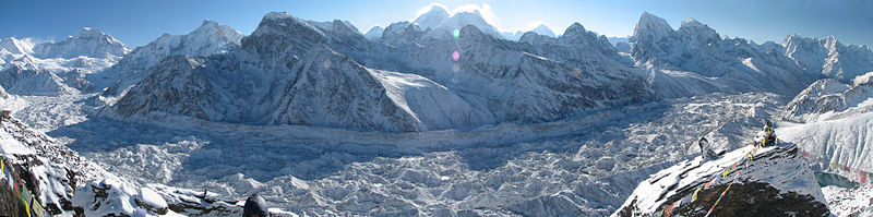
The sweep of the Ngozumba glacier (Nepal's longest) and encircling mountains clad in new snow as seen from Gokyo Ri just after sunrise. The sun rose just behind Everest (centre, left peak) and Nuptse/Lhotse (centre, right peaks). All the peaks are above 6000m. Main peaks visible (L to R) include (I think) Chakung (7029); Chunbu (6859); Cholo (6059), the closest at left of centre; Lobuche West (6145) and East (6119), centre; Everest, Nuptse and Lhotse tallest behind and above; Arakam Tse (5904); Cholatse (6440); and Taboche (6501). (if I've got them wrong, let me know...) You can see the 3rd Gokyo Lake at the bottom right |
| 日期 | |
| 来源 | Nepal - Sagamartha Trek - Ngozumba Gl from Gokyo Ri |
| 作者 | McKay Savage from Chennai, India |
| 相机位置 | | 在以下服务上查看本图像和附近其他图像: OpenStreetMap |
|---|
许可协议
| 这幅图片原始出处为Flickr的https://www.flickr.com/photos/56796376@N00/493506926 ,作者为mckaysavage 。经机器人FlickreviewR在2009年5月1日审查后确定为采用cc-by-2.0的协议授权使用。 |
| 註解 | 該圖片含有註解:在維基媒體共享資源上查看註解 |
文件历史
点击某个日期/时间查看对应时刻的文件。
| 日期/时间 | 缩略图 | 大小 | 用户 | 备注 | |
|---|---|---|---|---|---|
| 当前 | 2009年12月4日 (五) 13:55 | 7,497 × 1,863(3.06 MB) | Rupert Pupkin | bigger version | |
| 2009年4月30日 (四) 23:46 | 1,024 × 254(199 KB) | Gemini1980 | {{Information |Description= The sweep of the Ngozumba glacier (Nepal's longest) and encircling mountains clad in new snow as seen from Gokyo Ri just after sunrise. The sun rose just behind Everest (centre, left peak) and Nuptse/Lhotse (centre, right pea |
文件用途
以下页面使用本文件:
全域文件用途
以下其他wiki使用此文件:
- de.wikipedia.org上的用途
- en.wikipedia.org上的用途
- es.wikipedia.org上的用途
- fr.wikipedia.org上的用途
- hr.wikipedia.org上的用途
- sh.wikipedia.org上的用途
- www.wikidata.org上的用途