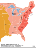
File:Map of territorial growth 1775.svg
外观

此SVG文件的PNG预览的大小:458 × 599像素。 其他分辨率:183 × 240像素 | 367 × 480像素 | 587 × 768像素 | 783 × 1,024像素 | 1,565 × 2,048像素 | 506 × 662像素。
原始文件 (SVG文件,尺寸为506 × 662像素,文件大小:507 KB)
文件历史
点击某个日期/时间查看对应时刻的文件。
| 日期/时间 | 缩略图 | 大小 | 用户 | 备注 | |
|---|---|---|---|---|---|
| 当前 | 2023年3月3日 (五) 05:13 |  | 506 × 662(507 KB) | Johnn Francis | Reverted to version as of 21:34, 7 January 2009 (UTC) This map describes the situation in the year 1775. Florida was acquired by Britain in 1763 from Spain (who would re-acquire it in 1783). Therefore Florida (both west and east) was British at the time this map is set. |
| 2022年12月19日 (一) 16:41 |  | 506 × 662(503 KB) | PatriaDeTodos | Florida was Spanish between 1513 and 1821 | |
| 2009年1月7日 (三) 21:34 |  | 506 × 662(507 KB) | Cg-realms | Fixed English text | |
| 2009年1月7日 (三) 21:18 |  | 506 × 662(231 KB) | Cg-realms | {{Information |Description={{en|1=Map of territorial growth, 1775. Adapted to vector graphics from JPG scan.}} |Source=Adapted from National Atlas of the United States scan uploaded by Kooma |Aut |
文件用途
以下页面使用本文件:
全域文件用途
以下其他wiki使用此文件:
- af.wikipedia.org上的用途
- als.wikipedia.org上的用途
- am.wikipedia.org上的用途
- ang.wikipedia.org上的用途
- ar.wikipedia.org上的用途
- arz.wikipedia.org上的用途
- ast.wikipedia.org上的用途
- azb.wikipedia.org上的用途
- be.wikipedia.org上的用途
- bg.wikipedia.org上的用途
- bh.wikipedia.org上的用途
- bn.wikipedia.org上的用途
- cs.wikipedia.org上的用途
- cy.wikipedia.org上的用途
- da.wikipedia.org上的用途
- de.wikipedia.org上的用途
- de.wikiversity.org上的用途
- el.wikipedia.org上的用途
- en.wikipedia.org上的用途
- American Revolution
- Thirteen Colonies
- Continental Congress
- Royal Proclamation of 1763
- Colonial government in the Thirteen Colonies
- User:Bob Palin
- Ohio Country
- User:Djr xi
- User:Djr xi/Userboxes
- User:Djr xi/User UK rule
- User:MrWeeble/Thirteen Colonies
- Indian Reserve (1763)
- User:Djr xi/Archive 4
- User:Ɱ/sandboxold4
- User:Ɱ/sandbox2
- List of modern great powers
- User:Joelton Ivson/Gather lists/24318 – Estados Unidos
查看此文件的更多全域用途。


