
File:Map of les saintes.gif
此为最大尺寸。
Map_of_les_saintes.gif (500 × 369像素,文件大小:14 KB,MIME类型:image/gif)
摘要
| 描述 |
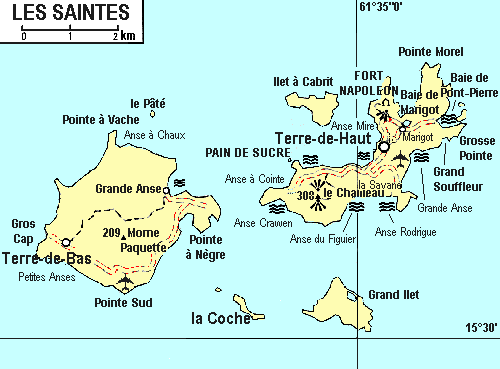
English: map of les Saintes, from 1993 |
| 日期 | |
| 来源 | Guide Visa-En Guadeloupe, 1993 |
| 作者 | Hachette Livre |
许可协议
| 本作品采用知识共享CC0 1.0 通用公有领域贡献许可协议授权。 | |
| 采用本宣告发表本作品的人,已在法律允许的范围内,通过在全世界放弃其对本作品拥有的著作权法规定的所有权利(包括所有相关权利),将本作品贡献至公有领域。您可以复制、修改、传播和表演本作品,将其用于商业目的,无需要求授权。
|
文件历史
点击某个日期/时间查看对应时刻的文件。
| 日期/时间 | 缩略图 | 大小 | 用户 | 备注 | |
|---|---|---|---|---|---|
| 当前 | 2011年12月4日 (日) 23:32 | | 500 × 369(14 KB) | Moowgly |
文件用途
以下页面使用本文件:
全域文件用途
以下其他wiki使用此文件:
- de.wikipedia.org上的用途
- el.wikipedia.org上的用途
- en.wikipedia.org上的用途
- Îles des Saintes
- Terre-de-Bas Island
- Terre-de-Haut Island
- Îlet à Cabrit
- Grand-Îlet
- Pompierre, Terre-de-Haut
- Marigot, Terre-de-Haut
- Vieille Anse, Terre-de-Haut
- Fort Napoléon, Terre-de-Haut
- Maison blanche, Terre-de-Haut
- La Coulée, Terre-de-Haut
- Coquelet, Terre-de-Haut
- Anse Mire
- Mouillage, Terre-de-Haut
- Grande-Anse, Terre-de-Haut
- Fond-du-Curé
- La Savane, Terre-de-Haut
- Anse Rodrigue, Terre-de-Haut
- Anse Galet, Terre-de-Haut
- Prés Cassin, Terre-de-Haut
- La Convalescence, Terre-de-Haut
- Anse Figuier, Terre-de-Haut
- Pain-de-Sucre
- Anse à Cointe, Terre-de-Haut
- Anse Crawen, Terre-de-Haut
- Anse des Mûriers, Terre-de-Bas
- Grande-Anse, Terre-de-Bas
- Grand-Baie, Terre-de-Bas
- Petite-Anse, Terre-de-Bas
- Le Mapou, Terre-de-Bas
- it.wikipedia.org上的用途
- ja.wikipedia.org上的用途
- nl.wikipedia.org上的用途
- pt.wikipedia.org上的用途
- ru.wikipedia.org上的用途
- uk.wikipedia.org上的用途
- ur.wikipedia.org上的用途
- vi.wikipedia.org上的用途
- www.wikidata.org上的用途