
File:Luxembourg administrative subdivisions coloured.gif
本预览的尺寸:444 × 599像素。 其他分辨率:178 × 240像素 | 600 × 809像素。
原始文件 (600 × 809像素,文件大小:30 KB,MIME类型:image/gif)
摘要
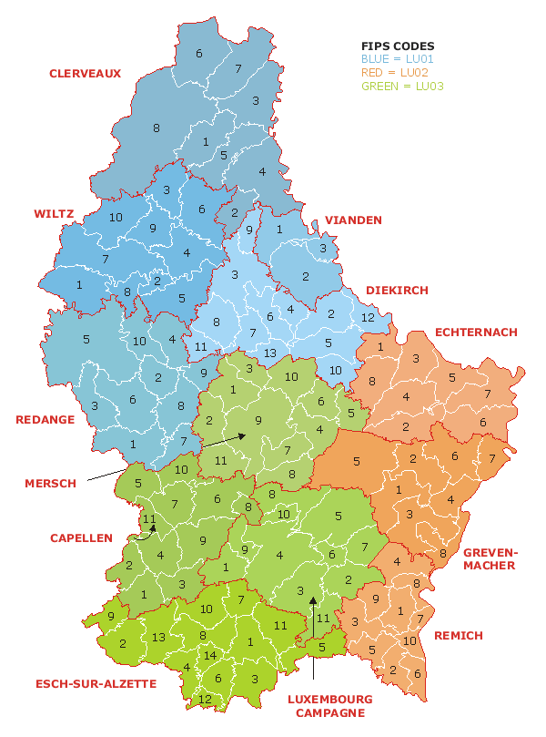
| 描述 | Map of the administrative divisions of Luxembourg. Districts, cantons, and communes are marked and numbered according to FIPS code. |
| 日期 | |
| 来源 | Own work based on w:Image:Luxembourg.geohive.gif, which previously had all rights released by its original author and publisher, GeoHive. Updated for the commune mergers of 2006-01-01. |
| 作者 | User:Bastin8 |
| 授权 (二次使用本文件) |
Released into public domain. See licence below. |

|
File:Luxembourg administrative subdivisions coloured.svg是此文件的矢量版本。 如果此文件质量不低于原点阵图,就应该将这个GIF格式文件替换为此文件。
File:Luxembourg administrative subdivisions coloured.gif → File:Luxembourg administrative subdivisions coloured.svg
更多信息请参阅Help:SVG/zh。 |
 |
许可协议
| 我,本作品著作权人,释出本作品至公有领域。这适用于全世界。 在一些国家这可能不合法;如果是这样的话,那么: 我无条件地授予任何人以任何目的使用本作品的权利,除非这些条件是法律规定所必需的。 |
文件历史
点击某个日期/时间查看对应时刻的文件。
| 日期/时间 | 缩略图 | 大小 | 用户 | 备注 | |
|---|---|---|---|---|---|
| 当前 | 2024年8月27日 (二) 20:08 | | 600 × 809(30 KB) | GiAnMMV | Corrected "Clerveaux" with "Clervaux". |
| 2006年7月21日 (五) 00:19 |  | 600 × 809(30 KB) | Bastin8 | {{Information |Description=Map of the administrative divisions of Luxembourg. Districts, cantons, and communes are marked and numbered according to FIPS code. |Source=Own work based on w:Image:Luxembourg.geohive.gif, which previously had all rights r |
文件用途
以下页面使用本文件:
全域文件用途
以下其他wiki使用此文件:
- an.wikipedia.org上的用途
- ast.wikipedia.org上的用途
- es.wikipedia.org上的用途
- eu.wikipedia.org上的用途
- fur.wikipedia.org上的用途
- gag.wikipedia.org上的用途
- id.wikipedia.org上的用途
- it.wikipedia.org上的用途
- kk.wikipedia.org上的用途
- ko.wikipedia.org上的用途
- lt.wikipedia.org上的用途
- mk.wikipedia.org上的用途
- nl.wikipedia.org上的用途
- pt.wikipedia.org上的用途
- ro.wikipedia.org上的用途
- ru.wikipedia.org上的用途
- sco.wikipedia.org上的用途
- sq.wikipedia.org上的用途
- tr.wikipedia.org上的用途
- uz.wikipedia.org上的用途