File:Great Britain 1789.svg
外观
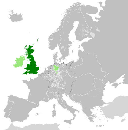
此SVG文件的PNG预览的大小:450 × 456像素。 其他分辨率:237 × 240像素 | 474 × 480像素 | 758 × 768像素 | 1,011 × 1,024像素 | 2,021 × 2,048像素。
原始文件 (SVG文件,尺寸为450 × 456像素,文件大小:848 KB)
文件历史
点击某个日期/时间查看对应时刻的文件。
| 日期/时间 | 缩略图 | 大小 | 用户 | 备注 | |
|---|---|---|---|---|---|
| 当前 | 2023年12月19日 (二) 16:42 |  | 450 × 456(848 KB) | Iktsokh | Cyprus paler grey |
| 2022年5月26日 (四) 11:17 |  | 450 × 456(846 KB) | Cyygma | Changing pale green to light green (more visible) | |
| 2021年10月17日 (日) 08:08 |  | 450 × 456(846 KB) | Fenn-O-maniC | Fixed the Russo-Swedish border to match the Treaty of Åbo of 1743 | |
| 2017年9月5日 (二) 16:20 |  | 450 × 456(857 KB) | Alphathon | Danzig | |
| 2017年9月5日 (二) 15:55 |  | 450 × 456(840 KB) | Alphathon | Added Brunswick-Lüneburg to British domains as it was rules in a personal union | |
| 2017年9月5日 (二) 15:45 |  | 450 × 456(840 KB) | Alphathon | Made Asia paler grey | |
| 2017年9月5日 (二) 15:34 |  | 450 × 456(840 KB) | Alphathon | == {{int:filedesc}} == {{Information |Description={{en|A map of the en:Kingdom of Great Britain circa 1789. Other British-held territories (Ireland, Mann, Channel Islands) are also shown in pale green.}}{{de|Eine Karte des [[:de:Königreich Groß... |
文件用途
以下2个页面使用本文件:
全域文件用途
以下其他wiki使用此文件:
- azb.wikipedia.org上的用途
- bn.wikipedia.org上的用途
- cs.wikipedia.org上的用途
- da.wikipedia.org上的用途
- de.wikipedia.org上的用途
- el.wikipedia.org上的用途
- en.wikipedia.org上的用途
- es.wikipedia.org上的用途
- eu.wikipedia.org上的用途
- fi.wikipedia.org上的用途
- fr.wikipedia.org上的用途
- fy.wikipedia.org上的用途
- gv.wikipedia.org上的用途
- he.wikipedia.org上的用途
- id.wikipedia.org上的用途
- it.wikipedia.org上的用途
- ja.wikipedia.org上的用途
- ko.wikipedia.org上的用途
- lo.wikipedia.org上的用途
- lv.wikipedia.org上的用途
- nds.wikipedia.org上的用途
- pt.wikipedia.org上的用途
- sco.wikipedia.org上的用途
- sk.wikipedia.org上的用途
- sl.wikipedia.org上的用途
- sq.wikipedia.org上的用途
- th.wikipedia.org上的用途
- tr.wikipedia.org上的用途
- uk.wikipedia.org上的用途
- vi.wikipedia.org上的用途
- www.wikidata.org上的用途
- xmf.wikipedia.org上的用途


