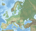
File:European Union relief laea location map.svg
外观

此SVG文件的PNG预览的大小:701 × 599像素。 其他分辨率:281 × 240像素 | 561 × 480像素 | 898 × 768像素 | 1,198 × 1,024像素 | 2,395 × 2,048像素 | 1,401 × 1,198像素。
原始文件 (SVG文件,尺寸为1,401 × 1,198像素,文件大小:1,018 KB)
文件历史
点击某个日期/时间查看对应时刻的文件。
| 日期/时间 | 缩略图 | 大小 | 用户 | 备注 | |
|---|---|---|---|---|---|
| 当前 | 2020年1月31日 (五) 23:20 |  | 1,401 × 1,198(1,018 KB) | Nablicus | update |
| 2013年7月1日 (一) 01:32 |  | 1,401 × 1,198(809 KB) | Seb az86556 | Reverted to version as of 11:50, 28 June 2013 | |
| 2013年6月28日 (五) 11:59 |  | 1,401 × 1,198(809 KB) | Nablicus | Reverted to version as of 10:28, 7 April 2010. Its 2 days and 12 hours left. Croatia is not a member yet. | |
| 2013年6月28日 (五) 11:50 |  | 1,401 × 1,198(809 KB) | Treehill | 1 day and less than 12 hours left, I think it's alright if we add it now. | |
| 2010年4月7日 (三) 10:28 |  | 1,401 × 1,198(798 KB) | Pethrus | {{Information |Description={{en|Topographic map of Europe with European Union highlighted * Projection: LAEA Europe, [http://spatialreference.org/ref/epsg/3035/ EPSG:3035] * Longitude of projection center: 10° E * Latitude of projection center: 52° N * |
文件用途
以下页面使用本文件:
全域文件用途
以下其他wiki使用此文件:
- ast.wikipedia.org上的用途
- ba.wikipedia.org上的用途
- be.wikipedia.org上的用途
- bxr.wikipedia.org上的用途
- cs.wikipedia.org上的用途
- de.wikipedia.org上的用途
- Europäische Union
- Liste der größten Städte der Europäischen Union
- Biathlon-Europameisterschaften 2012
- Demografie der Europäischen Union
- Biathlon-Europameisterschaften 2015
- Biathlon-Europameisterschaften 2017
- Biathlon-Junioreneuropameisterschaften 2016
- Biathlon-Junioreneuropameisterschaften 2017
- Biathlon-Weltcup 1987/88
- Biathlon-Junioreneuropameisterschaften 2022
- Benutzer:L.xschlag/Maps
- Biathlon-Junioreneuropameisterschaften 2023
- Biathlon-Junioreneuropameisterschaften 2024
- Biathlon-Junioreneuropameisterschaften 2025
- en.wikipedia.org上的用途
- eo.wikipedia.org上的用途
- es.wikipedia.org上的用途
- fa.wikipedia.org上的用途
- fr.wikipedia.org上的用途
- hif.wikipedia.org上的用途
- hu.wiktionary.org上的用途
- id.wikipedia.org上的用途
- it.wikipedia.org上的用途
- ku.wikipedia.org上的用途
- la.wikipedia.org上的用途
- mhr.wikipedia.org上的用途
- no.wikipedia.org上的用途
- pt.wikipedia.org上的用途
- ru.wikipedia.org上的用途
查看此文件的更多全域用途。

