
File:ElectoralCollege1808.svg

此SVG文件的PNG预览的大小:577 × 593像素。 其他分辨率:234 × 240像素 | 467 × 480像素 | 747 × 768像素 | 996 × 1,024像素 | 1,993 × 2,048像素。
原始文件 (SVG文件,尺寸为577 × 593像素,文件大小:45 KB)
| U.S. presidential election maps (SVG) |
| See also: National Atlas maps (png) |
|
1788-1789 · 1792 · 1796 · 1800 · 1804 · 1808 · 1812 · 1816 · 1820 · 1824 · 1828 · 1832 · 1836 · 1840 · 1844 · 1848 · 1852 · 1856 · 1860 · 1864 · 1868 · 1872 · 1876 · 1880 · 1884 · 1888 · 1892 · 1896 · 1900 · 1904 · 1908 · 1912 · 1916 · 1920 · 1924 · 1928 · 1932 · 1936 · 1940 · 1944 · 1948 · 1952 · 1956 · 1960 · 1964 · 1968 · 1972 · 1976 · 1980 · 1984 · 1988 · 1992 · 1996 · 2000 · 2004 · 2008 · 2012 · 2016 · 2020 · 2024 |
摘要
| 描述 | |
| 日期 | (Original); 2009-01-09 (Current) |
| 来源 | This image was adapted from File:ElectoralCollege1804.svg, itself adapted from File:Map of territorial growth 1775.svg and File:ElectoralCollege1964.svg (both based off File:Blank_US_Map.svg) using data from File:ElectoralCollege1808-Large.png, the original version uploaded by AndyHogan14, and the National Atlas of the United States |
| 作者 |
Cg-realms (current) AndyHogan14 (original) |
| 其他版本 | File:ElectoralCollege1808-Large.png |
| SVG development | W3C-validity not checked. |
许可协议
| 我,本作品著作权人,释出本作品至公有领域。这适用于全世界。 在一些国家这可能不合法;如果是这样的话,那么: 我无条件地授予任何人以任何目的使用本作品的权利,除非这些条件是法律规定所必需的。 |
文件历史
点击某个日期/时间查看对应时刻的文件。
| 日期/时间 | 缩略图 | 大小 | 用户 | 备注 | |
|---|---|---|---|---|---|
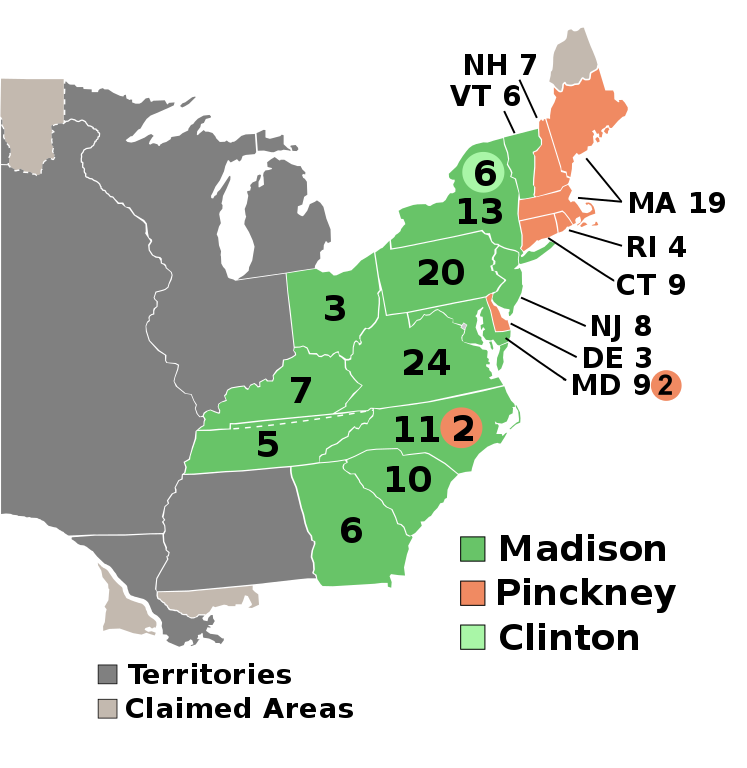
| 当前 | 2025年5月6日 (二) 17:45 | | 577 × 593(45 KB) | Rwv37 | (1) The vote counts for North Carolina were incorrect (Pinckney got three, not two - see https://www.britannica.com/event/United-States-presidential-election-of-1808). (2) The internal SVG markup had a North Carolina field IDed as being a New York field, and vice versa. Note that this had no effect on the actual display, because two separate mistakes regarding these effectively cancelled each other out. |
| 2025年3月13日 (四) 15:23 |  | 577 × 593(45 KB) | CFA | restore | |
| 2025年3月13日 (四) 14:05 |  | 577 × 593(125 KB) | GroverCleveland4 | restored (we can revert what we can want) | |
| 2025年3月13日 (四) 13:48 |  | 577 × 593(45 KB) | CFA | restore | |
| 2025年3月12日 (三) 23:48 |  | 577 × 593(125 KB) | GroverCleveland4 | Reverted to version as of 20:01, 26 February 2025 (UTC) | |
| 2025年2月27日 (四) 03:18 |  | 577 × 593(45 KB) | Interesting 2752 | Reverting mass reversion to oldest version of map | |
| 2025年2月26日 (三) 20:01 |  | 577 × 593(125 KB) | Ecotto29200 | Reverted to version as of 06:55, 9 January 2009 (UTC) | |
| 2024年11月20日 (三) 13:38 |  | 577 × 593(45 KB) | Arnapha | Clearer borders | |
| 2016年12月27日 (二) 02:19 |  | 577 × 593(122 KB) | Wow | Clinton | |
| 2016年11月14日 (一) 06:01 |  | 577 × 593(122 KB) | Wow | Maryland |
文件用途
以下文件是本文件的副本(更多细节):
以下页面使用本文件:
全域文件用途
以下其他wiki使用此文件:
- ckb.wikipedia.org上的用途
- cs.wikipedia.org上的用途
- da.wikipedia.org上的用途
- de.wikipedia.org上的用途
- el.wikipedia.org上的用途
- en.wikipedia.org上的用途
- Draft:2048 United States presidential election
- James Madison
- 1808 United States presidential election
- Presidency of Thomas Jefferson
- Electoral vote changes between United States presidential elections
- Presidency of James Madison
- List of United States presidential election results by state
- United States presidential election
- Template talk:Infobox election/Archive 4
- 1808 United States presidential election in Pennsylvania
- 1808 United States elections
- 1808 United States presidential election in Vermont
- 1808 United States presidential election in Connecticut
- 1808 United States presidential election in New York
- 1808 United States presidential election in New Jersey
- 1808 United States presidential election in South Carolina
- Template:State results of the 1808 U.S. presidential election
- Template:1808 United States presidential election imagemap
- 1808 United States presidential election in Ohio
- 1808 United States presidential election in Maryland
- 1808 United States presidential election in Massachusetts
- 1808 United States presidential election in Kentucky
- 1808 United States presidential election in Tennessee
- 1808 United States presidential election in Virginia
- 1808 United States presidential election in North Carolina
- 1808 United States presidential election in New Hampshire
- Draft:2040 United States presidential election
- 1808 United States presidential election in Rhode Island
- Draft:2060 United States presidential election
- Draft:2064 United States presidential election
- User:Falcaorib/United States presidential elections
- User:RapidsLurker15/United States presidential elections
- User:1aWIKIAL1,/sandbox
- es.wikipedia.org上的用途
- fa.wikipedia.org上的用途
- fi.wikipedia.org上的用途
- fr.wikipedia.org上的用途
- hu.wikipedia.org上的用途
- it.wikipedia.org上的用途
- ja.wikipedia.org上的用途
查看此文件的更多全域用途。