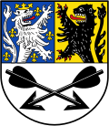
File:DEU Kall COA.svg
外观

此SVG文件的PNG预览的大小:463 × 532像素。 其他分辨率:209 × 240像素 | 418 × 480像素 | 668 × 768像素 | 891 × 1,024像素 | 1,782 × 2,048像素。
原始文件 (SVG文件,尺寸为463 × 532像素,文件大小:30 KB)
文件历史
点击某个日期/时间查看对应时刻的文件。
| 日期/时间 | 缩略图 | 大小 | 用户 | 备注 | |
|---|---|---|---|---|---|
| 当前 | 2023年2月9日 (四) 12:47 |  | 463 × 532(30 KB) | Jürgen Krause | little corrections - FIAV colours |
| 2013年1月3日 (四) 19:33 |  | 462 × 520(56 KB) | Jürgen Krause | == {{int:filedesc}} == {{COAInformation |blasoncz= |blasonnement-cz= |ref-cz= |blasonde=Gemeinde Kall |blasonnement-de=Die Gemeinde Kall ist mit Urkunde des Regierungspräsidenten in Köln vom 10. Juni 1974 das Recht zur Führung ein... |
文件用途
以下页面使用本文件:
全域文件用途
以下其他wiki使用此文件:
- be.wikipedia.org上的用途
- ceb.wikipedia.org上的用途
- ce.wikipedia.org上的用途
- de.wikipedia.org上的用途
- Kall
- Scheven
- Liste der Wappen im Kreis Euskirchen
- Benutzer:Wikoli/Portal
- Sötenich
- Steinfeld (Kall)
- Vorlage:Navigationsleiste Ortsteile von Kall
- Keldenich (Kall)
- Golbach
- Sistig
- Wahlen (Kall)
- Urft
- Krekel
- Benenberg
- Rinnen (Kall)
- Frohnrath (Kall)
- Steinfelderheistert
- Dottel
- Anstois
- Diefenbach (Kall)
- Gillenberg
- Wallenthal
- Wallenthalerhöhe
- Liste der Wappen mit dem Jülicher Löwen
- Vorlage:Navigationsleiste Naturschutzgebiete in Kall
- Auen und Hänge an Urft und Gillesbach
- Sistiger Heide
- Liste der Bodendenkmäler in Kall
- Kallbach und Rotzbach
- Roder (Kall)
- en.wikipedia.org上的用途
- eo.wikipedia.org上的用途
- es.wikipedia.org上的用途
- et.wikipedia.org上的用途
- fa.wikipedia.org上的用途
- fr.wikipedia.org上的用途
- hu.wikipedia.org上的用途
- it.wikipedia.org上的用途
- kk.wikipedia.org上的用途
- ku.wikipedia.org上的用途
- ky.wikipedia.org上的用途
- lld.wikipedia.org上的用途
- nl.wikipedia.org上的用途
- pl.wikipedia.org上的用途
- pt.wikipedia.org上的用途
查看此文件的更多全域用途。

