
File:DEU Kalkar COA.svg

此SVG文件的PNG预览的大小:478 × 592像素。 其他分辨率:194 × 240像素 | 387 × 480像素 | 620 × 768像素 | 827 × 1,024像素 | 1,654 × 2,048像素。
原始文件 (SVG文件,尺寸为478 × 592像素,文件大小:3 KB)
摘要
| 紋章 | Deutsch: Stadt Kalkar English: City of Kalkar Français : Ville de Kalkar |
|||
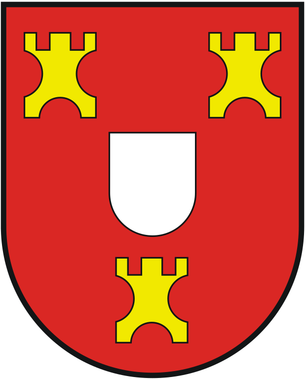
| 纹章描述 | Deutsch: Die Stadt Kalkar führt ein Wappen, ein Siegel und eine Flagge. „In Rot ein silberner (weißer) Herzschild begleitet von drei goldenen (gelben) Zinnentürmen im Verhältnis 2:1.“
Bereits im mittelalterlichen Siegeln Kalkars werden die Symbole mit dem silbernen Herzschild der klevischen Landsesherren gezeigt. Die drei Zinnentürme sind erstmals 1500 nachweisbar; sie sind in Anlehnung an das Klever Stadtwappen tingiert. English: „Gules, an escutcheon Argent accompanied by three merlon towers Or in ratio 2:1.“
Kalkar became a city early in the 13th century and was walled around 1250. The oldest known seal, dating from the 14th century, shows a castle, with on the middle tower the arms of the counts of Kleve, the city was part of the county of Kleve. The old arms of Kleve were a red shield with a white escutcheon. Later seals show on the tower arms like the present one, except that the towers are replaced by roses. The towers do not appear until the 15th century. The small towers finally replaced the main castle behind the shield. The arms thus did not change since the 15th century. In the 17th century and later a knight was often used as a supporter for the arms, but in 1974 when the arms were officially last granted, the supporter was omitted. |
|||
| 纹章描述参考资料 | ||||
| 日期 | ||||
| 艺术家 | unknown - Neubearbeitung des Wappens für die Stadt Kalkar durch Fabian Zohren. | |||
| 来源 | http://www.ngw.nl/int/dld/k/kalkar.htm | |||
| 授权 (二次使用本文件) |
|
|||
| 其他版本 |
本檔案衍生自: Kalkar-Wappen.png:  |
许可协议
文件历史
点击某个日期/时间查看对应时刻的文件。
| 日期/时间 | 缩略图 | 大小 | 用户 | 备注 | |
|---|---|---|---|---|---|
| 当前 | 2013年9月22日 (日) 18:34 | | 478 × 592(3 KB) | Jürgen Krause | purged - resized - FIAV colours |
| 2007年7月5日 (四) 23:54 |  | 815 × 939(4 KB) | FZohren | {{Information |Description= wappen der Stadt Kalkar |Source=self-made |Date= July 2007 |Author= Fabian Zohren }} |
文件用途
以下页面使用本文件:
全域文件用途
以下其他wiki使用此文件:
- ar.wikipedia.org上的用途
- azb.wikipedia.org上的用途
- be.wikipedia.org上的用途
- ca.wikipedia.org上的用途
- ce.wikipedia.org上的用途
- de.wikipedia.org上的用途
- Kalkar
- Wissel
- Appeldorn
- Kehrum
- Neulouisendorf
- Hanselaer
- Grieth
- Liste der Wappen im Kreis Kleve
- Vorlage:Navigationsleiste Ortsteile von Kalkar
- Hönnepel
- Kommando Operative Führung Luftstreitkräfte
- Niedermörmter
- Altkalkar
- Wisselward
- Benutzer:Beckstet/Kleve
- Joint Air Power Competence Centre
- Air Component Command
- Von-Seydlitz-Kaserne
- Emmericher Eyland
- Bylerward
- Benutzer:Dat doris/Liste der Naturdenkmale in Kalkar
- Liste der Bodendenkmäler in Kalkar
- Naturschutzgebiet Deichvorland bei Grieth mit Kalflack
- Naturschutzgebiet Wisseler Dünen
- Vorlage:Navigationsleiste Naturschutzgebiete in Kalkar
- Naturschutzgebiet Botzelaerer Meer
- el.wikipedia.org上的用途
- en.wikipedia.org上的用途
- eo.wikipedia.org上的用途
- es.wikipedia.org上的用途
- et.wikipedia.org上的用途
- eu.wikipedia.org上的用途
- fa.wikipedia.org上的用途
- fr.wikipedia.org上的用途
- hu.wikipedia.org上的用途
- io.wikipedia.org上的用途
- it.wikipedia.org上的用途
- ja.wikipedia.org上的用途
- kk.wikipedia.org上的用途
- ku.wikipedia.org上的用途
- ky.wikipedia.org上的用途
- lld.wikipedia.org上的用途
查看此文件的更多全域用途。