
File:Caucasiamapussr.gif
此为最大尺寸。
Caucasiamapussr.gif (700 × 590像素,文件大小:81 KB,MIME类型:image/gif)

|
File:Soviet Caucasus map.svg是此文件的矢量版本。 如果此文件质量不低于原点阵图,就应该将这个GIF格式文件替换为此文件。
File:Caucasiamapussr.gif → File:Soviet Caucasus map.svg
更多信息请参阅Help:SVG/zh。 |
 |
摘要
| 描述 |
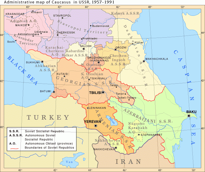
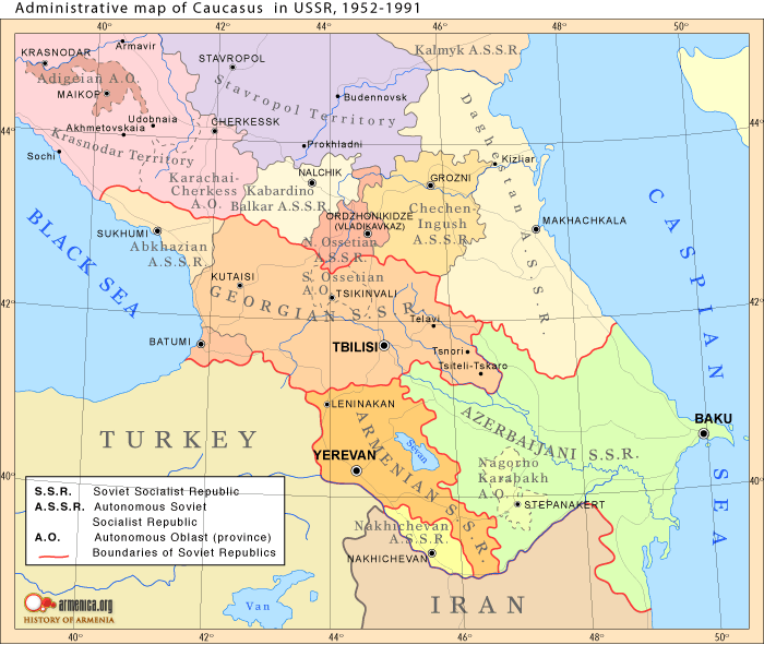
English: Administrative map of Caucasus in USSR, 1952-1991 |
| 日期 |
Uploaded to Armenica.org before 2006年12月7日 (archived version)
|
| 来源 | Originally uploded from en.wikipedia; description page is/was here. |
| 作者 | www.armenica.org |
| 其他版本 | العربيَّة |
许可协议

|
已授权您依据自由软件基金会发行的无固定段落及封面封底文字(Invariant Sections, Front-Cover Texts, and Back-Cover Texts)的GNU自由文件许可协议1.2版或任意后续版本的条款,复制、传播和/或修改本文件。该协议的副本请见“GNU Free Documentation License”。 |
This permission only applies to images existing on http://armenica.org/ as of 1 January 2007. Any later images do not fall under this permission!
原始上传日志
(All user names refer to en.wikipedia)
- 2007-01-03 03:06 Artaxiad 700×590×6 (60613 bytes) Administrative map of [[Caucasus]] in USSR, 1952-1991 Source: Armenica.org [[Category:Armenica images]]
文件历史
点击某个日期/时间查看对应时刻的文件。
| 日期/时间 | 缩略图 | 大小 | 用户 | 备注 | |
|---|---|---|---|---|---|
| 当前 | 2012年5月10日 (四) 16:30 | | 700 × 590(81 KB) | M0tty | Licence autorising modification → remove watermark |
| 2012年5月5日 (六) 20:03 |  | 700 × 591(78 KB) | Geagea | Original map according to the OTRS permission. Not to be reverted. | |
| 2011年3月27日 (日) 04:49 |  | 700 × 590(81 KB) | Hellerick | The earlier changes were correct. | |
| 2011年1月16日 (日) 19:12 |  | 700 × 590(59 KB) | Geagea | Reverted to version as of 10:16, 24 February 2007. To the uploader's last version | |
| 2011年1月16日 (日) 18:38 |  | 700 × 590(81 KB) | Nicolay Sidorov | Adygea to Krasnodar, Karachay-Cherkess to Stavropol. | |
| 2011年1月16日 (日) 18:31 |  | 700 × 590(80 KB) | Nicolay Sidorov | The Chechen-Ingush republic was restored on January 9, 1957 | |
| 2007年2月24日 (六) 10:16 |  | 700 × 590(59 KB) | Hardscarf | {{Information |Description=Administrative map of en:Caucasus in USSR, 1952-1991 |Source=Armenica.org {{ConfirmationImageOTRS|source=http://armenica.org/|otrs=2007010210006387}} Originally from [http://en.wikipedia.org en.wikipedia]; description page |
文件用途
没有页面链接到本图像。
全域文件用途
以下其他wiki使用此文件:
- ar.wikipedia.org上的用途
- azb.wikipedia.org上的用途
- az.wikipedia.org上的用途
- ca.wikipedia.org上的用途
- ckb.wikipedia.org上的用途
- el.wikipedia.org上的用途
- en.wikipedia.org上的用途
- et.wikipedia.org上的用途
- fi.wikipedia.org上的用途
- fo.wikipedia.org上的用途
- he.wikipedia.org上的用途
- hi.wikipedia.org上的用途
- hr.wikipedia.org上的用途
- id.wikipedia.org上的用途
- is.wikipedia.org上的用途
- ja.wikipedia.org上的用途
- jv.wikipedia.org上的用途
- ko.wikipedia.org上的用途
- nn.wikipedia.org上的用途
- no.wikipedia.org上的用途
- pl.wiktionary.org上的用途
- ro.wikipedia.org上的用途
- simple.wikipedia.org上的用途
查看此文件的更多全域用途。